Hiking log
- Elevation 410m
- When to climb Dec - May
- A 10km, 4.5 hour point-to-point course from Miyanohira station to Ome station. A longer 15km, 6 hour option to Hamura station is also available.
Mountain stats
About 90 minutes from Tokyo on the JR Chuo line to Miyanohira station.
An under 90-minute drive from Tokyo, although not many parking options available.
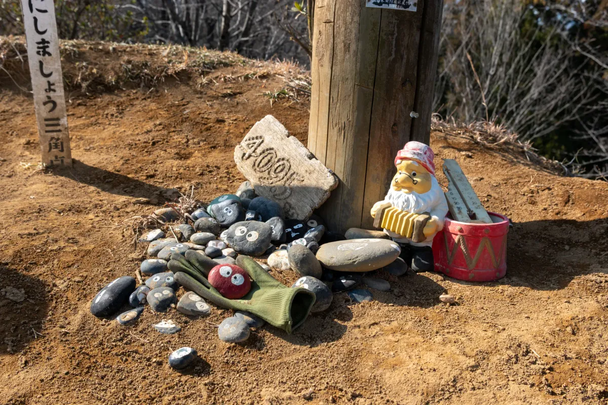
Akabokko (赤ぼっこ, akabokko) is a 410m elevation peak overlooking the town of Ome on the western edge of Tokyo. Thanks to its low elevation, it’s a great candidate for a beginner-friendly hike in the winter months. The summit and a number of points along the trail are also decorated with stones painted to look like the soot sprites from Ghibli films, which adds a bit of cuteness to the hike as well.
I’d occasionally seen Akabokko when scrolling through activity logs on YAMAP, usually with a photo of the rocks - and it had stuck in my mind as “the hike with the cute rocks”. It’s interesting how a little thing like that can make a mountain memorable!
My hike started off with a train ride to Miyanohira (宮ノ平) station on the Ome line. Today’s hike is conveniently a station-to-station hike.


The first 30 minutes of the hike is all along a road and will have you crossing over the Tama River (a long 138km river that flows all the way to Tokyo Bay).


It had snowed a week before in Tokyo, and so there were small remnants of it remaining here and there, but it had mostly all melted.


You’ll start to get some climbing in, but this course is overall not too steep, as it’s only 500m of elevation gain over a 10km hike. Within about 20 minutes of beginning your climb, you’ll get your first opportunity for a view.


The previous weekend had been so cold in Tokyo I was a bit worried about today, but actually the weather this weekend was really nice and warm - in Tokyo it reached 13°C (or 55 °F). Which is quite surprising for mid-February. But then I found out about the weather phenomenon “haru ichiban”, which is the first warm southerly wind that blows across Japan sometime between February and March. So maybe that happened this weekend?
And come to think of it, I did a hike to the Numazu Alps in mid-February two years ago which was also quite comfortably warm, so I suppose there’s precedent there. The idea of a warm breeze forecasting the coming of spring sounds quite nice, but apparently it also involves strong winds, and the sudden melting of snow causing avalanches. So not all good news.

Back on the main trail, I spotted my first soot sprite, or makkuro-kurosuke. They’re featured in two of Ghibli’s films - My Neighbour Totoro (a childhood classic for me) plus Spirited Away, which is what really catapulted Studio Ghibli to fame in the west.

And I was so focused on the next set of soot sprites that I didn’t even realise this was the peak marker for Mt Yogai (要害山). At 414m, I suppose this is the highest peak on the course.


Beyond Mt Yogai, I passed a clearing where they were doing some logging.


As you keep hiking, there’s the option to take a 10-minute detour out to the Tengu-iwa (天狗岩) viewpoint. You can get similar views from the peak of Mt Akabokko itself, but I still think it’s worth checking out this one.


From Tengu-iwa, you can see out to the town of Ome below.

And looking closely, the bridge in the foreground of the picture might possibly be the same one I crossed at the start of my hike across the Tama River.

Then you’ll retrace your steps back onto the main trail, and head towards Akabokko.


Akabokko is marked by one lone tree.


And of course, you’ll be greeted by all of the soot sprite stones I mentioned at the start of this post. It seems like there’s also been the addition of a Snow White dwarf playing the accordion.


From the peak, you can get a similar view out to the town of Ome, in case you missed checking out the view from Tengu-iwa.


And a little bit too hazy today, but out to the right you can see out as far as the Tokyo Skytree.

If you look at this hiking log, it seems the peak is also decorated with pink Japanese azalea flowers if you come in May so that might not be a bad time to visit too.

There was also a sign at the summit explaining how Akabokko got its name. During the 1923 Kanto earthquake, the topsoil around the peak collapsed to show reddish dirt, and hence the locals began calling this peak Akabokko (“aka” meaning red in Japanese).
Once I had a quick snack break, I started my descent. You can’t zone out too much here, as the trail has you at times almost doubling back on yourself. The next waypoint you’ll be aiming for is the Mabikizawa Pass (馬引沢峠).


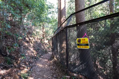
Once you reach the black fence, you’ll want to keep it on your right.


At certain intervals they had stuck up pictures of birds - possibly what you can see in the area?

And then quite randomly, a pole marking a Bato-kannon (馬頭観音) - a Buddhist deity that is worshipped as a guardian of livestock, and for safe travels. Apparently this statue was placed here in 1774. Wow, that’s old.

Unfortunately this cool artefact is marred by the rather loud garbage dump that is right on the other side of the fence.

Plus a rather ominous bear warning sign.

When googling Akabokko in Japanese, the top suggested result is “Akabokko bears”, although none of the search results themselves have much to do with actual bear sightings. Maybe either people get scared by this sign and Google for it, or maybe since it’s a beginner-friendly mountain a higher amount of people want to know whether it’s safe to hike or not.
I’m not too sure about whether there are bears, but the one thing I would recommend you doing is Googling what a Japanese serow looks like, as they are quite commonly spotted on this trail (and could kind of look like a bear from a distance). And if you do spot one, you have nothing to worry about as they are quite afraid of humans themselves.

Once you’ve reached the Mabikizawa Pass, the next waypoint you’ll be aiming for is Tenso Shrine (天祖神社).


Along the way, you’ll even pass a graveyard.

While on this hike, I had been thinking about how even though you are probably surrounded by birds in the forest, it is surprisingly hard to get a good picture of one. And then out popped this Daurian redstart, who was quite happy to flit back and forth and pose for me.


A mejiro even decided to join in on the fun too.


For a brief moment you’ll walk along the road leading to the graveyard (and I think there’s a toilet around here if you need one).

Before you rejoin the trail, and pass a cute mushroom hut.


And before you know it, you’ll have descended down to the Tenso Shrine, which marks the end of the hiking part of this course.


From here, you have a 30 minute walk through the town of Ome, and to Ome station.


Along the way, you’ll once again pass back over the Tama River.

Where I spotted a Great egret fishing in the distance.

As I approached Ome station, I was rather bemused by the number of cat-themed signs.


From a quick Google, apparently Ome used to have three independent cinemas in the Showa era, and a local man painted billboards to advertise the movies. Even after the Showa era ended, he continued to paint retro movie-themed art for the town in order to try and boost its tourism. After he passed away though, the town decided to do a pivot to cats, but kept in the movie theme by doing cat-themed movie posters instead. Which I find to be pretty funny. Considering it made me stop and look, I think it worked pretty well.

Finally, the hike finishes at Ome station, where you can get on a train that conveniently takes you all the way back to Tokyo in only 80 minutes.
Hiking course options
| Date climbed | Length | Course time |
|---|---|---|
| 2026-02-13 | 10km | 4h22min (the expected time for an average hiker without breaks) |
This is a 10km point-to-point course starting at Miyanohira station and ending at Ome station. The two stations are adjacent stops, and so you can really do this course in either direction, but since Ome station is the one closer to Tokyo, as a personal preference I like the return train journey to be a bit shorter (even if it’s only marginally!)
Also Ome station is a bit more lively, so it is probably the better option if you are looking for lunch or a snack before heading home.
If you are looking for a slightly longer course, YAMAP has this alternate 6-hour and 15km hike which finishes at Hamura station (羽村駅).
Public transport access
This hike has great public transport access. From Tokyo station, you’ll take the JR Chuo line all the way to Ome station, and then transfer trains to go one more station to Miyanohira station (宮ノ平駅). If you time your trip well and get one of the faster rapid trains, you can get from Tokyo to Miyanohira in 90 minutes.
Your hike then finishes at Ome station (青梅駅) where you can get on a direct train all the way back to Tokyo.
Car access details
I wouldn’t necessarily recommend coming by car due to how fast the train is out of Tokyo, but if you do, there is a small carpark at the Kamanofuchi Park (釜の淵公園駐車場) which is a small park near-ish to Ome station.
When to hike Akabokko
Mt Akabokko can be hiked year around without snow, which makes it an ideal candidate for a winter hike. There’s azaleas that bloom at the summit in early May, so that could be another good time for a hike as well.
Due to its low elevation though, hiking in summer would be really rough and I would advise against it, not to mention there would probably be a lot of bugs.
Read more


Recent posts
 hikes
hikesShould you be scared of bears when hiking in Japan?
8 Apr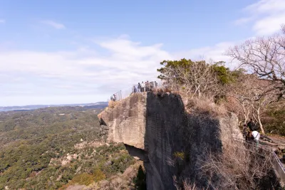 hikes
hikesMt Nokogiri: a hike to Chiba's stone quarry
18 Mar hikes
hikesMt Miura-fuji and the Miura Kaigan Cherry Blossom Festival
9 Mar
Leave a comment