
Over the past 4 years of hiking in Japan, I’ve had the pleasure of spotting Mt Fuji on numerous occasions (as well as climbing it too). I’ve compiled a list with some of my favourite hikes to get a view of Mt Fuji from both the Fuji Five Lakes area, as well some hikes that are slightly further away, but still provide some great views, such as the Tanzawa mountains and Mt Daibosatsu.
I find that setting out on a hike with the expectations of meeting Mt Fuji can be a bit of a gamble. Sometimes that promise of a Fuji view ends up with a feeling of disappointment when the peak is obscured by some pesky clouds. Other times, I wasn’t planning on seeing Mt Fuji at all, and it’s such an unexpected yet lovely surprise when I turn a corner or get above the treeline, and there it is. The best feeling is when Fuji is nowhere to be seen, but then the clouds miraculously part - giving you the time to snap some pictures before it disappears again.
What is the best month to see Mt Fuji on a hike?
Statistically speaking, your chances of seeing Mt Fuji are much higher when it’s cold. You’ll have a more than 80% chance of seeing Mt Fuji in February, while you’ll only have about a 30% chance in September (source). So I generally recommend aiming to hike between November and April.
However it can also be a bit of a balancing act as you need to factor in the elevation of the mountain. Mountain peaks at an elevation of 1500m, for example, will be covered in snow in February and become a no-go.
On the flipside, even if you manage to get a clear visibility day in summer (it’s rarer, but it can still happen) I generally wouldn’t recommend climbing most of the mountains on this list. Japanese summers are very hot, and you can be at a risk of heat-stroke hiking lower elevation mountains at this time. Not to mention the bugs. I would recommend instead making the most of summer and heading to the Japanese Alps.
Before jumping into the full list, here’s a month-by-month summary of the best hikes near Mt Fuji, factoring in both visibility odds and the elevations you can hike at.


- January: Your chances of seeing Mt Fuji are at 70% in January, and you can hike up to an elevation of 1500m in the first half of January before the snow sets in - this makes Mt Ishiwari and Mt Kintoki great options for early January
- February: February has the highest visibility chances at over 80%, but you’ll need to stay at fairly low elevations (below 1000m) to avoid snow. Mt Ono is a standout highlight as you can get some good unobstructed views, while Mt Takao and Mt Jinba are the best options closer to Tokyo


- March: The snow will begin to clear in March, and visibility chances remain good at 70%. Towards the end of March, Mt Iwadono is a great option if you want to sneak in some cherry blossom viewings.
- April: In April your visibility chances drop to 60%, but as things start to warm up you can head for the slightly higher elevation mountains like Mt Mitsutoge.


- May: May is the last month where you have good odds of seeing Mt Fuji, and before the summer heat sets in - although it will be getting pretty warm! It’s also now warm enough to head to Mt Daibosatsu, the only 2000m-range mountain on this list.

- June: June is the rainy season in Japan (known as “tsuyu”), and with poor visibility chances, it’s honestly not a great time to attempt to plan a hike
- July - September: The rainy season can continue into July, and with August and September being the hottest months, visibility chances drop to as low as 30%. I might recommend Mt Daibosatsu just because it’s a slightly higher elevation hike, but it’s pretty borderline and if anything I would recommend you head outside of Tokyo to higher elevation mountains where it’s cooler.
- October: Even though October starts to see the temperatures drop, your Mt Fuji visibility chances are still only 40%. However mid-October also brings the start of the beautiful autumn leaves (koyo) season to mountains like Mt Daibosatsu and Mt Mitsutoge which gives an excuse to hike, even if you might not spot Mt Fuji


- November: In November, the autumn leaves season is in full-swing and visibility jumps back to over 60%, making it a great time for a hike. Mt Oyama and Mt Odake in particular have some great autumn scenery.
- December: With the temperatures dropping, but visibility chances high, in December you can still hike mountains up to an elevation of 1500m, making most of the mountains on this page still feasible!
Hiking in the Fuji Five Lakes Area
There are five main lakes around Mt Fuji, known as the “Fuji Five Lakes”, which let you get up-close-and-personal with Mt Fuji. If you’re wanting to escape the crowds of popular viewpoints like the Chureito Pagoda or the Lawson Conbini (ha) then a hike is a really nice choice.
There are a lot of little mountains around Mt Fuji, so below I’ve provided hiking options for each of the Five Lakes.
Mt Mitsutoge (Lake Kawaguchiko)

Mt Mitsutoge
Lake Kawaguchiko is the most accessible of the Fuji Five Lakes, and so the nearby Mt Mitsutoge is at the top of my list. From Kawaguchiko station, it’s a 25 minute bus ride to the Mitsutoge trail head (三ッ峠登山口) bus stop. From here, you can do a 12km, 5.5 hour course up to the peak and then back to Kawaguchiko station.
For those wanting an even longer trail, you can also do a 15km station-to-station hike starting at Mitsutoge station and ending at Kawaguchiko station. I had the opportunity to do this in late March, and got to pass a lot of beautifully flowering sakura trees that I would have otherwise missed, so it was quite a nice hike!
Mt Ishiwari (Lake Yamanakako)

Mt Ishiwari
Lake Yamanakako is the largest of the Fuji Five Lakes, and is also the closest lake to Mt Fuji. The nearby Mt Ishiwari lets you get a great view of both the lake and Mt Fuji in the same shot. Although there’s no train station nearby, conveniently there is the option to get a highway bus directly from Shinjuku station to the trailhead, where you can do a 5 hour hiking trail up to the peak, and then back down to the lake.
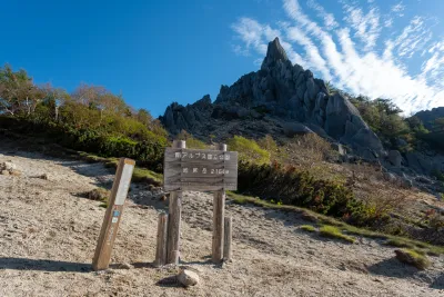
Mt Ryugatake (Lake Motosuko)

Mt Ryugatake
Mt Ryugatake is next to Lake Motosuko, the third-largest (but deepest) of the Fuji Five Lakes. Its trailhead is at the Lake Motosuko bus stop (本栖湖バス停), which is a 50 minute ride from Kawaguchiko station. From here, you have a beginner-friendly 6km loop course that should take you 4 hours. I also have to make a shoutout to Mt Amagatake and Mt Kenashi, which neighbour Mt Ryugatake on either side. If you were looking for a longer hike, there’s multiple hiking options here, including a 14km, 9.5 hour course that passes all three.
Lake Motosuko also has a rather large campground, so if you’re interested in camping, you can spend the night here before setting out for your hike the next morning.
Mt Odake and Mt Onigatake (Lake Saiko)

Mt Odake and Mt Onigatake
Mt Odake and Mt Onigatake are two peaks close to Lake Saiko that can be done as a loop hike. Its trailhead is at “Iyashi no Sato”, which is a tourist spot in its own right, and can be accessed by a 40min bus from Kawaguchiko station. This hike felt like a bit of a hidden gem - there are some spots on a exposed ridgeline where you can get some really great views of Mt Fuji. I would class it in the “hard” category only since the hike is over 6 hours, and there are small sections where you have to navigate a steep rock with a rope.
Mt Sanpobun (Lake Shojiko)

Mt Sanpobun
Lake Shojiko is the smallest of the Fuji Five Lakes, and is also the least-developed. So I found Mt Sanpobun to be quite nice if you want to get away from the crowded Lake Kawaguchiko! You can get Fuji views from both the trailhead and the Panorama-dai partly up the trail. I quite like how from Lake Shojiko you can see this cute little mound in front of Mt Fuji. The course is an 8.5km loop, and takes 5 hours.
Myojinyama (Lake Yamanakako)

Myojinyama
You’ll notice so far I have listed one mountain for each of the five lakes, but I couldn’t help but mention Myojinyama on here as well as a second option for Lake Yamanakako. I wouldn’t recommend it as a proper hike, as it’s quite a short 1.6km trail from the trailhead to the summit, but it came with one of my favourite views ever of Mt Fuji. The trailhead is best accessed by a car, as the public transport options are quite limited.
Hakone area: Mt Kintoki
Hakone is a popular tourist destination with plenty of opportunity for Mt Fuji views, including the Owakudani ropeway or the iconic boat ride on Lake Ashi. If you’re wanting to do a hike though, Mt Kintoki is the best hike in Hakone to see Mt Fuji. If you are just doing it as a day trip from Tokyo, you’ll probably need to make the hike the main event of the day (I don’t think you’ll have much time to head to the other major tourist spots) but if you have a couple of days it can be nice to dedicate a day to along with your other sightseeing.

Mt Kintoki
Moving out of the Fuji Five Lakes Area, another beginner-friendly mountain that is still quite close to Mt Fuji is Hakone’s Mt Kintoki. Accessible via a highway bus from Shinjuku to the Kintoki shrine trailhead (金時神社入口) the peak of Mt Kintoki has a rather large axe you can take a photo together with.
As well as the 3 hour course from the trailhead, there’s also the option to keep hiking past Mt Kintoki to the neighbouring Mt Myojingatake (明神ヶ岳) for a total 6.5hr, 11.5km course.
Hiking in the Tanzawa mountains (Kanagawa)
A little further away from Mt Fuji, the Tanzawa mountain range is my next favourite place to see Mt Fuji. I actually find that since you are on the eastern side of Mt Fuji you can get some really nice photos without any glare thanks to the sun being at your back.
Mt Oyama

Mt Oyama
Mt Oyama is the most beginner-friendly mountain in the Tanzawa mountain range, with cable car access making it doable as a 3 - 4 hour hike. From Tokyo, it’s a 75-minute train ride to Isehara station, then a 30-minute bus to the Oyama Cable bus stop. You’ll be able to spot Mt Fuji from near the top of the trail.
Mt Ono

Mt Ono
Mt Ono is another great 4-hour hike to get a clear view of Mt Fuji, with the hike only taking 4 hours. The trail starts at Yaga station - no buses required. With the low elevation, you will be able to climb it for much of the year as well. This is probably the most convenient hike you can do in the Tanzawa area.
Mt Tonodake

Mt Tonodake
Mt Tonodake and the neighbouring Mt Tanzawa are popular mountains for locals living in the Kanagawa area. To reach the Okura trailhead, you’ll be looking at a 2-hour trip from Tokyo, taking a local bus via Shibusawa station. At 8 hours round trip the trail is long, but well-maintained, and so can make for a great training mountain if you’re looking to get some hikes in during the colder months. Of course, not to mention the amazing view of Mt Fuji which you’ll start to spot from partway up the trail.
Mt Nabewari

Mt Nabewari
Another Tanzawa mountain that can be hiked from the Okura trailhead is Mt Nabewari. It’s particularly popular for the nabeyaki udon sold at its summit. If you’ve already climbed Mt Tonodake or Mt Tanzawa and are looking for another Tanzawa mountain to check off of your list, Mt Nabewari is another great option.
Mt Iwadono (Yamanashi)
If you’re heading to the Five Lakes area by train, you’ll pass Mt Iwadono along the way - so this is a nice hike if you don’t want to have to travel all the way to Kawaguchiko.

Mt Iwadono
The hike to Mt Iwadono conveniently starts from Otsuki station, which is only a 65-minute train ride if you take a limited express train from Shinjuku station. If you time your hike for late March / early April, you can be just-in-time to catch the views of Mt Fuji together with the blooming cherry blossoms at Maruyama Park.
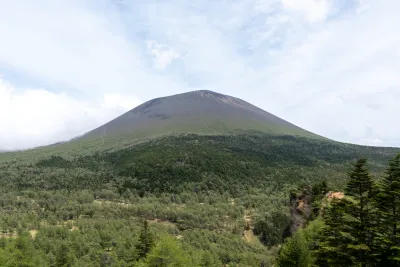
Mt Daibosatsu (Yamanashi)

Mt Daibosatsu
At 2056m, Mt Daibosatsu is the highest in elevation of the mountains on this list, and is quite a far bit away from Mt Fuji compared to the Five Lakes region, but I think seeing it together with the Kamihikawa dam makes for a pretty cool shot. The standard loop course is only 3 - 4 hours, so this is another beginner-friendly option with some great views.
Mt Daibosatsu is particularly popular in autumn, when you can enjoy the colours of the autumn leaves (or “koyo”). It’s a 3-hour trip from Tokyo, with a shuttle bus departing from Kai-Yamato station.
Day hikes from Tokyo with a Mt Fuji view
On a clear day, you can actually see Mt Fuji from Tokyo (albeit far off in the distance) if you head up somewhere high like the Tokyo Skytree. So your next best bet if you don’t want to travel too much, is to head to one of the mountains nearest to Tokyo.
Mt Takao

Mt Takao
With only an elevation of 599m, your view of Mt Fuji from Mt Takao will be slightly obscured by the mountains in front of it, but it is possible to see it on a clear day! I would say Mt Takao is the best hike near Tokyo to see Mt Fuji just with how easily accessible it is - it’s under an hour by train from Shinjuku station.
Access is via train on the Keio line to Takaosanguchi (高尾山口) station. There’s a cablecar and chair lift, so you can do the hike in under an hour. I would say Mt Takao is great if you are looking to spend a bit of time in nature and check out its temple, without doing too much of a strenuous hike.
Mt Jinba

Mt Jinba
Directly next to Mt Takao is the peak of Mt Jinba, which comes with a rather suspicious-looking horse statue. From here you can also spot Mt Fuji, and your view should be a little bit better than from Mt Takao as you are another 200m up in elevation. Mt Jinba’s hiking course will take you 7 hours, and is a 15km course that ends at Mt Takao.
If you’re looking to go to Mt Jinba, you’ll need to get the train to Takao (高尾) station - note this is a different train station to where you’d get off for Mt Takao - and then a 30 minute bus to Jinba-kogen (陣馬高原).
Mt Mitake and Mt Odake

Mt Mitake and Mt Odake
Mt Mitake has a number of hiking courses, but if you hike out to the neighbouring Mt Odake (a 9km hike) you’ll get a chance to see Mt Fuji at its summit. Public transport access is 2 hours by train from Tokyo to Mitake station on the JR Chuo line, and then a 10 minute bus trip from the station to the Mitake cablecar.
Mt Fuji’s visibility forecast
If you want to increase your odds of seeing Mt Fuji, as I mentioned at the start of the post, you’ll want to go in the colder months. There is also this “When to See Mt. Fuji?” website which provides a visibility forecast, so you can try and time your chances.
According to this source, your odds of seeing Mt Fuji are higher in the early morning, which I have found to be true - sometimes I’ll be on the train or driving to the trailhead, and spot Mt Fuji along the way, but then it completely disappears by the time I start my hike. If you spot Mt Fuji, I would recommend getting a photo of it while you can!
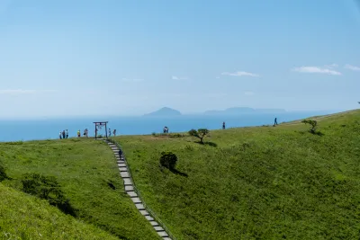
How far away can you see Mt Fuji?
As a final fun fact, did you know you can see Mt Fuji from as far away as Gunma? I have spotted it from the peak of Mt Shibutsu - which is 175km away. Apparently you can see it from 323km away in Wakayama too which is pretty crazy.


Comments
Thank you for sharing my blog here :) really love your website and I'm using it a lot for hiking planning. I hope to climb as many hyakumeizan as you have
Leave a comment