Hiking log
- Elevation 1949m
- When to climb June to October
- 4.5h (9.5km) for the full course, but can also be shortened to 1 - 3 hours.
Mountain stats
3 hours from Tokyo via shinkansen to Fukushima station, then bus to Jododaira Rest House.
Parking at Jododaira carpark (500 yen). Accessed via Bandai-Azuma Skyline road.
Mt Azuma-Kofuji (吾妻小富士, azuma-kofuji) and Mt Issaikyo (一切経山, issaikyo-zan) are two adjacent peaks in Fukushima which can be climbed together as a set. After first doing a quick loop of the crater of Mt Azuma-Kofuji (“Kofuji” aptly means “Mini Fuji”), you can then climb up to the neighbouring Mt Issaikyo to get an awesome shot of it looming from a distance.
I climbed these two mountains back in 2023, but was reminded of this hike when I visited the nearby Mt Nishi-Azuma just last weekend, so thought I’d do a write-up for it! Funnily, the only public transport option in 2023 was to bundle this together with a grape-picking tour so that made for a pretty interesting experience as well.

My hike began at 10am when the tour bus dropped me off at the Jododaira Rest House (浄土平レストハウス). The trails out to Mt Issaikyo and Mt Azuma-Kofuji lead out in opposite directions from here, so you can climb them in either order. If you’re short on time, I would recommend choosing Mt Issaikyo since I think that has the better views. I had plenty of time though, so I decided to start with Mt Azuma-Kofuji! It was a quick 40 minute loop around its crater.

It was quite foggy and a little rainy at first, but luckily things started to clear up.


With the loop done, it was back down to the rest house and then out to the trail on the other side.


Once you start to head away from Mt Azuma-Kofuji, you get to really appreciate its unique shape.

As you begin your climb, the Kananuma Pond (鎌沼) also comes into view in the distance.


The climb up is a short one, so you should be at the summit of Mt Issaikyo within an hour.

From here, you can see out to the Goshikinuma Lake, also known as the Majo-no-Hitomi (“The Witch’s Eye”).

The peak also comes with views out to the city of Fukushima.

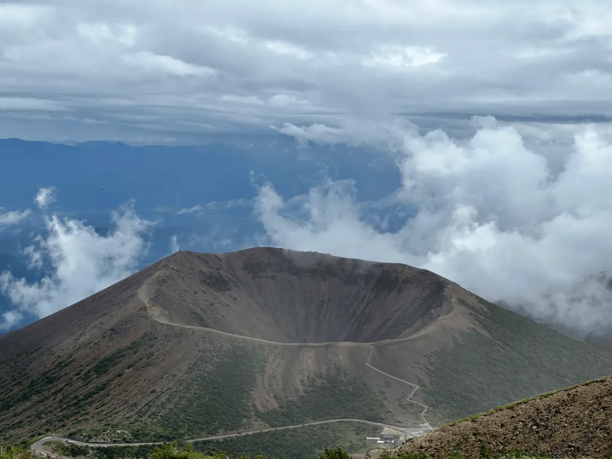
And of course, from near the summit you can get the best views of Mt Azuma-Kofuji.

The crater rim of Mt Azuma-Kofuji is not necessarily a rare phenomenon in Japanese mountains - it takes its name from Mt Fuji itself, after all. But I think what’s really unique about this hike is the fact that you can get a view of it from above like this (and not from a plane). I’m sure this hike is also very beautiful in the autumn foliage season!

Once you’ve taken in the views, you can head back down the same way you came. If you’re short on time, you can head straight back to the Jododaira Rest House. Alternatively, you can take an hour-long detour route and head around the Kananuma Pond that you would have seen on your climb up.


Once back at the rest house, I had a bit of time to kill until the 2pm bus, but luckily there’s some food options available. The bus service running in 2025 doesn’t depart until 15:30, so in that case you would have even more time (so no point rushing the hike!)

The bus ride is a long and windy 90 minutes along the Bandai-Azuma Skyline back to Fukushima station.

And since my bus tour came with a grape-picking experience, we had a stop there along the way. Basically the tour setup was “all you can eat” and not “all you can pick” - so you could pick a bunch, eat it on the spot before you pick another bunch, and so on.

Once back at Fukushima, I got a train to Koriyama station where I spent the night, in preparation for my hike the next day to Fukushima’s Mt Bandai.
Hiking course options
| Date climbed | Length | Course time |
|---|---|---|
| 2023-09-23 | 9.5km | 4.5h (the expected time for an average hiker without breaks) |
The full hiking course I did comes out to 9.5km, but you can shorten the hike in a number of ways:
- Skip climbing Mt Azuma-Kofuji
- Skip the loop detour around the Kananuma Pond
If I were to pick the one peak, I would go for Mt Issaikyo as it has the best views!
Public transport access
In 2025, there was a “Jododaira Sky Access” (浄土平スカイアクセス) bus running daily from the beginning of May. You need to book the tickets in advance on their website, which comes out to 10,000 per person round trip. It looks like the busses stop running at the beginning of November.
The bus picks you up from Fukushima station west exit at 8:30am. You can get to Fukushima via a 90-minute Shinkansen from Tokyo, so this hike is doable even if you start your day in Tokyo. Once the bus drops you off at the Jododaira Resthouse, you have 5.5 hours, which is plenty of time to do the entire hiking course. Finally you’ll be dropped off back at the station at 5pm, so you can head home or spend a night in the area.
Note that the reservation site also has a separate 2-hour plan for non-hikers, so make sure you pick the correct one.
In 2023, I did this hike with a tour package that also came with some grape-picking. Looks like something that was only running in 2023 so I guess I got lucky!

Car access details
The Jododaira carpark (浄土平駐車場) has parking with a fee of 500 yen. I would expect that the carpark could get quite popular in weekends during the autumn foliage season (late September - late October) so I would keep that in mind when planning your trip.
Jododaira is accessed via a long road known as the Bandai-Azuma Skyline (磐梯吾妻スカイライン). It’s only accessible from May to mid-November each year due to snow, so outside of this window you won’t be able to hike this mountain. You can Google for “磐梯吾妻スカイライン通行止め” to try and find the most up-to-date information on the road closures.
When to hike Mt Azuma-Kofuji and Mt Issaikyo
Whether coming by car or bus, the road up to the trailhead is blocked off during the winter months, so you can only climb this mountain between May and the beginning of November. The road opening dates will vary a little year-on-year so you will need to double-check if you are coming at the start or end of this period.
If you want to skip the snow, you will probably want to come between June and November. For example in the 2025 season, you look at the end of April and see that the trail is still quite snowy. By the end of May it has mostly melted but there is still some remaining.
Read more


Support me
📸 Thanks for reading! If you'd like to read more posts like this one, you can follow me on Instagram to stay up to date on my hiking adventures.
If you found this post useful, you can show your support by buying me a coffee - I write this blog for fun, but coffee is always appreciated! ☕
Recent posts
 hikes
hikesMt Nokogiri: a hike to Chiba's stone quarry
18 Mar hikes
hikesMt Miura-fuji and the Miura Kaigan Cherry Blossom Festival
9 Mar hikes
hikesAkabokko: hiking in Ome
16 Feb
Leave a comment