Hiking log
- Elevation 1470m
- When to climb April - December
- For those coming by car, there is a loop course available, plus a point-to-point course if you are coming via public transport.
Mountain stats
A little under 3 hours from Tokyo via train and bus to Dozakazuido (道坂隧道) bus stop.
A small carpark at the trailhead, a 90 minute drive from Tokyo.
Near the beginning of 2024 I visited Mt Imakura (今倉山 Imakura-yama), one of the Hundred Famous Mountains of Yamanashi and the neighbouring Mt Akaiwa (赤岩 Aka-iwa), which comes with 360 degree views of the surrounding mountain ranges.

Although this mountain is in Yamanashi, it felt surprisingly close to Tokyo with only a 90min drive to reach the trailhead. The mountain isn’t a very popular one, and so the carpark is quite small. When I visited on Friday it was completely empty and I was the first car there. I only ended up passing one other hiker that day.


The hike up to Mt Imakura is 80% of the climbing you’ll do for this course, so once you’ve reached this peak it’s smooth sailing from here.


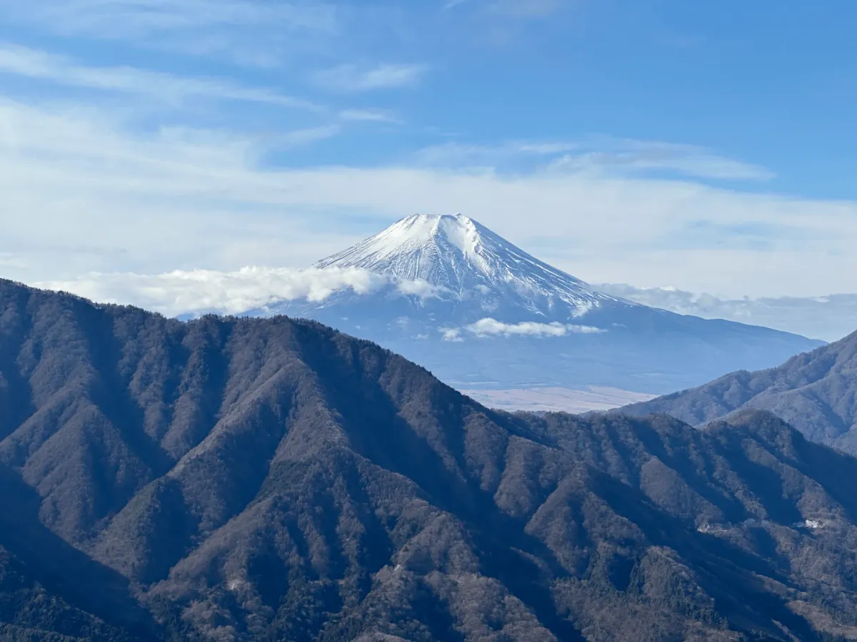
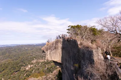
The second peak, Mt Akaiwa, is the highlight of the hike with views in every direction. I was blessed with clear skies and no wind - I managed to squeeze in this hike just before we had rain forecast on the weekend.


From here it’s a descent down to the third and final summit, Mt Nijurokuya (二十六夜山 Nijurokuya-san).

Apparently it’s given this name because in the Edo period there was a tradition of eating and drinking on the mountaintop while waiting for the moon to rise on the 26th of July. This peak also has good views of Mt Fuji, at a slightly lower elevation of 1297m.

Note: This is also named Doshi-Nijurokuya (道志二十六夜山) and is not to be confused with the lower elevation Akiyama-Nijurokuya (秋山二十六夜山) which has an elevation of 972m. (Thanks David for pointing this out!)
Finally it’s about an hour walk down the road back to the trailhead. The road was closed off though so there’s no danger of passing any cars here. I also got my final glimpse of Mt Fuji.


As you approach the main road, there’s the option to return to the carpark via walking along it, or to take a trail on the left.

I opted to take the trail back, but quickly regretted my decision. There was pink ribbons (used on Japanese trails to mark where you are supposed to go) however the trail looked pretty under used.
Maybe it was my own fault, but I found it hard to actually find the proper trail and so I found myself walking through the leaves and bushes while searching for pink ribbons. I definitely recommend going via the road instead!
Before starting on my journey home, I stopped by an onsen in the town of Tsuru.

This was probably the most high-tech onsen I’ve ever been to. Instead of lockers with regular keys, you get a wristband with an IC chip on entry that lets you swipe to open your locker, and any food purchases are charged to your wristband. On exit, you pay off the bill.
Funnily although, as modern as this onsen facility was, it still banned tattoos.
Public transport access
I’m not too sure how great the public transport options are, although it doesn’t look 100% impossible. There is a point-to-point course available, and looking at other YAMAP users, they seem to start at at the carpark where I started my hike (there is a bus stop there called 道坂隧道) before ending at 芭蕉月待ちの湯バス停. You can check out Ridgeline Images’ post where he has climbed Mt Imakura with public transport.
You’ll first need to get a train to the closest train station, which is probably 都留市 (Tsurushi).
Hiking course details
| Date climbed | Length | Course time |
|---|---|---|
| 2023-01-19 | 8km | 4h40m (the expected time for an average hiker without breaks) |
This is an out-and-back course that that starts and ends at 今倉山登山道入口 (Imakura-yama Tozandou-iriguchi).
There is a toilet available across the road from the car park.
Car access details
| Car park | Time (from Tokyo) | Round trip cost |
|---|---|---|
| 道坂トンネル駐車場 (どうざかトンネル ちゅうしゃじょう) | 1h50m | ~7400 yen |
There is a small car park at the trailhead that can possibly fit up to 8 cars. I would recommend not getting there too late just to be on the safe side, although it doesn’t look to be a very popular mountain so you might be ok.
Read more


Support me
📸 Thanks for reading! If you'd like to read more posts like this one, you can follow me on Instagram to stay up to date on my hiking adventures.
If you found this post useful, you can show your support by buying me a coffee - I write this blog for fun, but coffee is always appreciated! ☕
Recent posts
 hikes
hikesMt Nokogiri: a hike to Chiba's stone quarry
18 Mar hikes
hikesMt Miura-fuji and the Miura Kaigan Cherry Blossom Festival
9 Mar hikes
hikesAkabokko: hiking in Ome
16 Feb
Leave a comment