Hiking log
- Elevation 855m
- When to climb Jan - May, October - Dec
- A 15km, 6 - 7 hour traverse course to Mt Takao, or a shorter 4 hour loop if you just want to hike Mt Jinba.
Mountain stats
A little under 2 hours from Tokyo. Train to Takao station and then a bus to Jinba-kogen Shita bus stop.
The public transport options are great, so not recommended by car.
Mt Jinba (陣馬山, jinba-san) is an 855m peak on the borders of Tokyo and Kanagawa prefectures. Although it can be climbed by itself, it’s also commonly done as a traverse course to the popular Mt Takao for those who are looking for a bit of a challenge. At 15km, the course is quite long, but the smooth trails and long stretches of flat sections make for a rather comfortable 6 - 7 hour hike.
It had been a couple of years since I visited Mt Jinba, so I decided to make it my first hike of 2026. Thanks to its low elevation it’s also a good candidate for hiking in the colder winter months when you’re not sure what to hike.

After a 40-minute bus ride from Takao station, you’ll get off at Jinba-Kogen Shita, the last stop on the bus route. From here, it’s a 30-minute walk up a road before you get to the actual trailhead.


Overall the trail is quite nice, but the hardest part is probably this first climb on the course, as you do a steep 400m of elevation gain in one go.


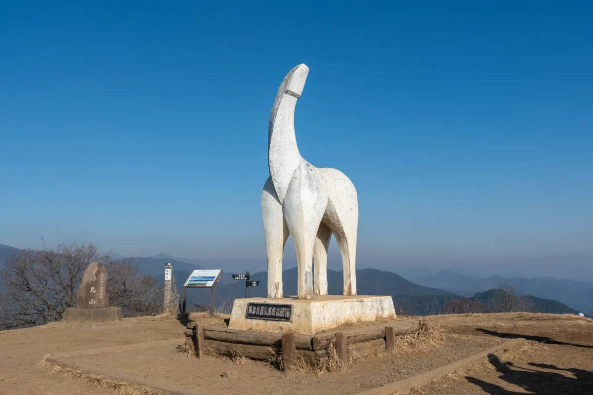
But within about an hour’s climb, you’ll make it to the summit of Mt Jinba! And at the peak, you’ll be greeted with the most suspicious-looking horse statue I have ever seen.


The “馬” in 陣馬 means “horse” which explains the horse, and it was installed in the late 1960s as a way to promote tourism to the area. It’s only as I began climbing that I remembered that 2026 is the Year of the Horse so this makes for a very fitting hike to kick off the year.
There are two huts serving food on the peak here, which speaks to the mountain’s popularity, plus a great view of Mt Fuji if you get lucky enough with the weather.


From here, it’s an up-and-down traverse course all the way to Mt Takao. Along the way you’ll pass a couple of other peaks in the area.


Along the way you’ll pass a granite marker for the Kanto Fureai Trail (関東ふれあいの道).

Apparently this is an 1800km long trail, split out into smaller sections (seems like they are not all connected so you can’t walk the entire thing in one go). Walking from the Jinba Kogen-shita bus stop to Takaosan-guchi (the end of today’s hike) is a portion of the trail known as the “鳥のみち” or “Bird Path”.
The next point of interest is Myoo Pass (明王峠).

It has a tea house which seemed to at least have been operational in 2019 but closed down at some point since - although one person notes they were attempting to do some renovation on it in 2023-24.


For a bit of a change in scenery, you’ll also pass one small stretch that’s had all the trees logged.


The course has a number of junctions where you can take a left or right, and I think sometimes one may have a tiny bit more elevation gain than the other, and the other provides a slight shortcut. As long as you are heading in the direction of Mt Kagenobu (景信山) you will be on the right track.
Eventually you will come to a steep descent - keep your eyes peeled for a trail heading to the right once you reach here…

Or you may have to retrace your steps up the hill a bit. All of us kept on descending before realising we had missed a turning off point (oops). From here you’ll have a brief climb before you reach the next peak - Mt Kagenobu (景信山).


This one is a very popular peak in its own right, as it’s only a 70-minute hike from the nearest bus stop. There were plenty of people enjoying their lunch in the winter sun here. Mt Kagenobu will take 3 - 4 hours to reach from the start of the hike, so it can be a good stopping point for lunch if you don’t mind the crowds.

And from Mt Kagenobu, you’ll get another opportunity to spot Mt Fuji as you begin your descent.


As you descend off Mt Kagenobu, you’ll come across a little patch of tanuki statues.

It seems like at one point it was used as a marker for Kobotoke Pass (小仏峠) if I look at this photo on Wikipedia, but maybe that marker has since fallen over.

There was also a man selling some tenugui with designs like this one - could be cute if you are looking for a souvenir.


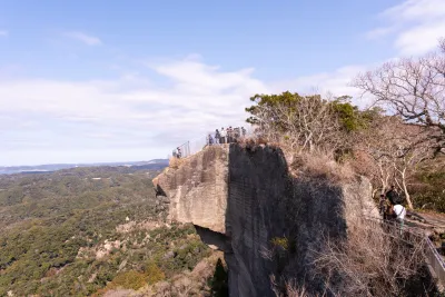
After another climb, you’ll come to the second-to-last peak on this hike - Mt Kobotoke-Shiroyama (小仏城山). It should take you about an hour between Mt Kagenobu and here.


Similar to Mt Kagenobu, this peak was super lively with hikers enjoying their lunch. From here, you’ll have a final 1-hour hike to reach Mt Takao.


I was able to hike a little faster than expected, and arrived at Mt Takao around 1pm - a little under 5 hours into my hike. But if you are following the expected course times, I would expect it to take at least 6 hours.
For those who have read my blog post on Mt Takao, you’ll remember I hiked it on a Friday morning, and managed to get a nearly empty shot of the peak marker at Mt Takao. I had no such luck today, as it was 1pm on a Saturday, and so it was super packed with people.

From the peak, you have a number of course options to get off the mountain. If you’ve never hiked Mt Takao before, I would recommend descending via Trail 1 since that lets you walk through the temple complex (you can see the photos for it on my previous Mt Takao post).

If you want to take a completely forested route all the way down, you’ll want to take the Inariyama trail down from the summit (that’s the route I used to climb in my Mt Takao post). Your other alternative is trail 4, which I took today - it passes by a small suspension bridge.

Once you step onto trail 4, the drop in the number of people is immediately noticeable, and it feels much more peaceful.


Trail 4 doesn’t take you all of the way down the mountain though, so you’ll eventually join back up with all the people coming from trail 1.

Mt Takao has a “Banksy” who updates the decorations on this one tree stump - last time I visited it was Christmas-themed.

It seems like it’s been updated to promote some event to visit the statues of 8 lucky gods in the nearby town of Hachioji (“hachi” also meaning 8). In the Japanese calendar system 2026 is the 8th year of the Reiwa era so with the 3 eights, it’s super lucky (8 is a lucky number in Japan).

I decided to stop off for a snack. Freshly grilled dango seems to be quite popular on Mt Takao, but I decided to go for a niku-man, or steamed pork bun.

And then faced with the prospect of walking another 1.5km down the concrete road back to the station, I decided to skip some of the walk and take the chairlift back down instead. Kind of lame of me, I know, but this was my 8th time climbing Mt Takao so I think you can forgive me for trying it just this once.


From there, I walked back to Takaosanguchi station, and hopped on a train straight back home to Tokyo. Mt Takao does have an onsen at the station if you are so inclined, although I’ve never been curious enough to try it out (would rather just head home, really).
All-in-all, it was a pretty good hike to start off the new year.
Hiking course options
| Date climbed | Length | Course time |
|---|---|---|
| 2026-01-17 | 15.7km | 6h56min (the expected time for an average hiker without breaks) |
This is the standard Mt Jinba to Mt Takao traverse course, which passes Mt Kagenobu and Mt Kobotoke-Shiroyama along the way.
If you want to end at the same bus stop, you can also do a shorter loop course variant for Mt Jinba. However with the 40-minute bus ride back the station, it is a little annoying - I think ideally you should try and plan for a hike that ends at Mt Takao to make your return a little easier.
So if you were looking for a slightly shorter option, you can skip Mt Jinba, and instead do the traverse from Mt Kagenobu to Mt Takao which is a more reasonable 8km over 4 hours (if you end at the Takao cablecar station).
Of course, just doing a Mt Takao loop is another viable option, which I have covered previously in my Mt Takao post.
In terms of toilet access - there are plenty at all the various huts along the trail. The ones up on the mountain ridge may be squat toilets (I think from memory a couple of years ago either the Kagenobu or Shiroyama one was?) so if you are squeamish about that idea I would try target the ones at the station and the one directly after you get off the bus.
Public transport access
From Shinjuku station, it’s just under an hour by express train to Takao station (高尾駅) on the JR Chuo line, and then a 40 minute bus ride to the Jinba-Kogen Shita (陣馬高原下) bus stop.
Make sure not to get Takaosanguchi station (on the Keio line) confused with JR’s Takao station, as they are two completely different stations.
Once you get off the train, you’ll want to head for the north exit, and the number 1 bus stop. There will probably be a long line of hikers so it’s hard to miss. As well as regular all-stops buses, at peak times they do express buses just for hikers who are all heading to Jinba-Kogen (which is the last stop on the line). If you can’t understand Japanese it may be a bit hard to figure out which line to stand in, but if you follow all of the other hikers you probably are in the correct place.

The bus takes IC (Suica/Pasmo) cards, which you tap both when you get on and off.
The return hike will have you end at Takaosanguchi station on the Keio line, which has express trains running to Shinjuku. It’s a pretty convenient hike public transport-wise.
Car access details
I wouldn’t recommend doing this course via car, since it is a traverse course. Generally it’s such a popular area with hikers, and the public transport is so good, that I wouldn’t say its worth it. There does seem to be a loop course variant for Mt Jinba, but I’m not sure what your odds are of finding a carpark around the trailhead. I didn’t really see any hikers coming via car.
When to hike Mt Jinba
With only a max elevation of 855m at Mt Jinba, and most of the hike hovering around the 500-600m elevation range, this is one of the few mountains you can mostly hike through winter. Personally, I’ve hiked the same trail in late February with no snow. Of course, there may be some times during the middle of winter where there is a bit of snow, so I would encourage you to look at other people’s hiking logs on YAMAP - both of people taking the same course as well as activities logged that pass by Mt Jinba to get a sense of the conditions before your hike.
On the flip-side, I wouldn’t encourage you to be hiking this one in summer (June - September) due to how hot it gets. One time I did this same course in late May and I remember that being quite a hot and exhausting experience. I’m sure you can get some really yummy shaved ice to cool you down at the huts along the trail though.
Read more


Support me
📸 Thanks for reading! If you'd like to read more posts like this one, you can follow me on Instagram to stay up to date on my hiking adventures.
If you found this post useful, you can show your support by buying me a coffee - I write this blog for fun, but coffee is always appreciated! ☕
Recent posts
 hikes
hikesMt Nokogiri: a hike to Chiba's stone quarry
18 Mar hikes
hikesMt Miura-fuji and the Miura Kaigan Cherry Blossom Festival
9 Mar hikes
hikesAkabokko: hiking in Ome
16 Feb
Leave a comment