Hiking log
- Elevation 1212m
- When to climb mid-March - May, October - mid-January
- A short 3-hour loop course from Kintoki Shrine or the option to extend it out to a 6.5-hour, 11.5km traverse to Mt Myojingatake.
Mountain stats
Not recommended, but there is a small carpark near the shrine trailhead.
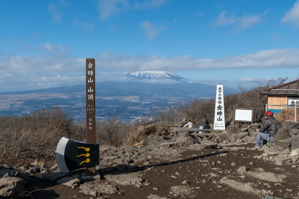
Mt Kintoki (金時山, kintoki-yama) is a beginner-friendly hike that can be done as 3-hour loop course from Kintoki Shrine. From the top, you can pose with a large axe that is used as a summit marker, and get an amazing shot of Mt Fuji if the weather is on your side. If you’d like to extend your hike further, you can also do a traverse to the neighbouring Mt Myojingatake (myojin-ga-take) with some really pretty ridgeline views, before you descend off the mountain and get on a bus back to Hakone.

Arriving at the Kintoki shrine trailhead, you’ll be greeted by a Evangelion-themed toilet. If you’re not familiar, Evangelion is a super classic Japanese anime and is actually set in Hakone (although it’s renamed to Tokyo-3 in the anime), so there’s a lot of Evangelion-related stuff around Hakone.

As you begin your hike past the Eva toilet, there’s another funny sight - some free-roam chickens.


And then there’s the red torii gate leading up to the shrine itself. Directly behind the shrine is the peak of Mt Kintoki visible in the distance.

It wasn’t until I started researching a bit for this blog post that I realised, but actually this shrine is briefly featured in the Evangelion anime, which probably explains the themed toilet.


Around the shrine and as you begin your hike, there’s a number of signs explaining the history of this mountain. Mt Kintoki takes its name from the legend of Kintaro, a child raised on the mountain and who wielded an axe to defeat monsters.


It should take you up to 90 minutes to make it up the summit. Along the way, you can get views out to a rather large golf course.


There had been some clouds swirling about in the morning, but I had hopes that maybe as I had been climbing they would have disappeared, and maybe I would get a clear shot of Mt Fuji.

Unfortunately not quite a clear shot today, although I at least got to see Fuji’s midriff.


There’s a shop here at the summit that sells baked sweet potatoes (yum) and other dishes like soba and curry udon.


And of course, you’ve got to get your photo with the large axe / peak marker at the summit! Even for a Friday, there were plenty of people around so it took a while of waiting to get this clear shot.
If you’re wanting to do the 4-hour loop hike, from the summit you would continue onwards down to Otome Pass (乙女峠) and then back to the Shrine trailhead. Alternatively, if you want the shorter 3-hour course, you’ll retrace your steps back to the trailhead.

If you want to head onwards towards Mt Myojingatake, there’ll be a junction point on the return trip where you head straight instead of going right.

The first part of the trail is a long descent, before you slowly climb your way back up along the ridgeline.


You might have spotted the mountain with smoke coming out of it on the way up, but as you head towards Mt Myojingatake you’ll be able to get a better view of it. it’s the Owakudani Valley - probably the most popular tourist attraction in Hakone. It has active sulphur vents which explains the smoke.
Since I was heading towards Mt Myojingatake, I was expecting the trail to be a lot quieter, but I was surprised by the amount of people I passed heading up towards Mt Kintoki. At first I assumed they were all coming from Myojin and doing the course in reverse.

As it turns out there are a couple more trailheads to climb Mt Kintoki, so I assume people who come via car will park at one of these and make the climb up from this way.

One of the unique features of this hike is that large portion of the traverse between Mt Kintoki and Mt Myojingatake is along this path that cuts through a huge field of sasa, also known as bamboo grass.
And although you are heading in the opposite direction of Mt Kintoki, I would recommend periodically taking in the views behind you, as they are pretty good as well.


And the more you gain in elevation, you’ll begin to see Mt Fuji poking over the hills to the left of Mt Kintoki.


There’s a small stretch of forest, where I spotted a flock of what looked to be ヤマガラ or “varied tit”. They were quite noisy and seemed to be bashing some seeds (?) against the branches.


With a final look back towards Mt Kintoki before you reach Mt Myojingatake, you might be able to spot the peak of Mt Fuji lined up perfectly behind the peak of Mt Kintoki.


Eventually you’ll come to peak of Mt Myojingatake. In total I would expect it to take 3 hours from the peak of Mt Kintoki to reach the peak of Mt Myojingatake. There’s quite a long stretch without any good break spots in between so I was feeling pretty tired.


From near the summit you can get a great view out to what is probably the city of Odawara below.

It’s pretty crazy how far the city seems to stretch.
From the peak, you’ll have 90 minutes remaining on your hike. Make sure you don’t miss the turn off point, as if you zone out and keep going straight you might overshoot it. (Which I managed to do the last time I did this hike).

From here’s there’s a bit of a steep descent down a rocky mountain path.


Eventually you’ll come back to civilization, although you don’t quite get back on a road just yet, as you will follow a straight path that runs past the backywards of people’s houses.

It gets dark quite quickly in winter (before 5pm) so if you are feeling nervous you could probably get off the trail and walk along the road instead.

Eventually you’ll be back on the road for the final 10 minute walk to the Miyagino-annai-jou (宮城野案内所) bus stop.

Hiking course options
| Date climbed | Length | Course time |
|---|---|---|
| 2025-12-19 | 11.5km | 6h30min (the expected time for an average hiker without breaks) |
Mt Kintoki and Mt Myojingatake probably both have quite a number of courses where you can climb one or both of them, but if I were to list the 3 that I mentioned in this blog post:
- Kintoki Shrine out-and-back (3.8km): the most direct route, which can be done in just under 3 hours
- Kintoki Shrine loop course (5.6km): a slightly longer route, taking 4 hours, which takes you via Mt Nagao (長尾山) and Otome-toge pass (乙女峠)
- Mt Kintoki and Mt Myojingatake traverse (11.5km): the course I took. This is expected to take 6.5 hours and will end at the Miyagino-annaijo-mae bus stop where you can get a bus back to Odawara station.
A digital hiking map is also available here.
Public transport access
Shinjuku -> Mt Kintoki shrine trailhead
Access to Mt Kintoki is made super convenient by a highway bus that runs from the bus terminal at Shinjuku station called Busta Shinjuku (バスタ新宿). If you exit via the South exit of Shinjuku station, it’s directly across the road so it’s hard to miss. The express buses depart from the fourth floor.
You’ll want to get off at the Kintoki Shrine trailhead (金時神社入口), and the bus journey will take two hours.
You will need to book a spot on the bus using j-bus.co.jp in advance, and make sure you don’t forget to pay for your booking (the booking system lets you reserve first and then pay later). Afterwards you can get a QR code which is your bus ticket (there is a link in the email) which becomes available 2 hours before you board.
I got on the earliest 6:35am bus and the bus timetable has you arrive at the trailhead at 08:39. With a little bit of traffic, we arrived closer to 9am. When I last did this hike a couple of years ago, there was really bad traffic on the freeway and ended up arriving a bit after 10am, so I recommend giving yourself a little leeway in your schedule to account for the potential traffic.
Mt Kintoki shrine trailhead -> Shinjuku
If you are doing a loop course, you’ll end your hike at the same shrine trailhead. You can get an express bus back to Shinjuku, which is the most convenient, although the one downside is that if you book in advance you will make sure you have to time your descent right so you don’t miss it. If you have spare time, there are some food options near the trailhead so that could be a good option to waste some spare time as well.
The alternative is to walk 1km down the road to Sengoku where you can get a local bus to Hakone-Yumoto or Odawara stations.
Miyagino-annaijo-mae -> Shinjuku
If you are doing the traverse course to Mt Myojingatake, you’ll finish at the 宮城野案内所前 bus stop (bit of a mouthful) which you can see on Google Maps here. It’s actually the same local bus that I mentioned in the section above, just at a section further along on the route.
The buses are quite frequent - the ones with a double circle in the photo below will terminate at Odawara station (about a 35 minute trip), while certain ones will terminate part-way along the route at Hakone-Yumoto station.
If you are wanting to do a bit of sightseeing, buy some Evangelion merch, or stop off at an onsen, Hakone-Yumoto station will be the better choice. However going via Odawara will ultimately get you back to Shinjuku quicker (maybe a difference of about 1 hour).

Car access details
I would recommend coming to Mt Kintoki by bus. There is some limited parking available (see here) near the shrine trailhead, but not a large amount for how popular it is.
When to hike Mt Kintoki
With an elevation at the summit of 1212m, there may be snow on the summit of Mt Kintoki between January and March. When I climbed Mt Kintoki in 2023, all the snow had already melted at the beginning of March, but snowfall can vary year-on-year.
So that would put the snow-free season at sometime in March - sometime in January. However especially if you are doing the hike between Mt Kintoki and Mt Myojingatake, there are large stretches of exposed trail without any shade, so I wouldn’t recommend attempting this hike in the summer months - it will get pretty hot.
To see the latest trail conditions, you can check out the trail logs here on YAMAP.
Read more


Support me
📸 Thanks for reading! If you'd like to read more posts like this one, you can follow me on Instagram to stay up to date on my hiking adventures.
If you found this post useful, you can show your support by buying me a coffee - I write this blog for fun, but coffee is always appreciated! ☕
Recent posts
 hikes
hikesMt Nokogiri: a hike to Chiba's stone quarry
18 Mar hikes
hikesMt Miura-fuji and the Miura Kaigan Cherry Blossom Festival
9 Mar hikes
hikesAkabokko: hiking in Ome
16 Feb
Leave a comment