Hiking log
- Elevation 599m
- When to climb Year-round
- Expect a 90-minute hike if you use the cable car, or 3 hours without.
Mountain stats
55 minutes by train from Shinjuku station (or 80 minutes from Tokyo) to Takaosanguchi station on the Keio line. The hike starts directly from the station.
Paid parking available, but public transport is recommended.
Mt Takao (高尾山, takao-san) is the most-climbed mountain in Japan, and is great if you’re looking for a quick escape from the city, as it’s conveniently located only an hour’s train ride from Shinjuku station. If you take the cable car you’ll be at the 599m elevation summit in under an hour, with some views of Mt Fuji if you are lucky. Of course, Mt Takao’s popularity also means that there are large crowds, and if you take one of the easier routes, it’s more of a long walk up a paved path rather than a true hiking experience.
Depending on what you are looking for, Mt Takao might not be the hike for you - if you want to spend some time alone in nature, there are a lot of other great hikes in Tokyo that I would recommend checking out. But if you’ve never hiked before, or you’re wanting to try solo hiking for the first time, Mt Takao can be a pretty good beginner-friendly option. Also, it is the most convenient mountain to hike in Tokyo, so it’s nice if you just want a quick hike before you get on with the rest of your day.

Starting at Takaosanguchi station, you’ll first head along a short road to the left of the wooden station building. I started my hike at 8:30 on a Friday, anticipating that maybe it would be a little bit quieter, but there were still plenty of people about!

After a 5 minute walk, you’ll make it to the Takao cable car station. If you take the cable car up, it’ll drop you near the Takaosan Yakuoin Temple, from which it’ll be under an hour’s hike to the summit. Even without the cable car, a loop course will only take you 3 hours, so I decided to skip it.

When you first arrive at the cable car station it is a little bit confusing on where you are supposed to head next. If you are wanting to take the easiest trail up - Trail 1 - take a right and head up the road.

Otherwise, there are two other options to climb - Trail 6 and the Inariyama trail - which start to the left of the cable car building. I think both of these are good options if you want to try and escape the crowds. I’ve visited Mt Takao at least 5 times in the 3+ years I’ve lived in Tokyo, and I’ve always stuck with trail 1, so I was looking forward to trying something different today.

I decided to head up the Inariyama trail because apparently that was the “hardest” trail (although it’s still pretty beginner-friendly). In hindsight, Trail 6 has you pass the Biwa waterfall which sounds pretty cool so I would probably go for that option next time.

Although there were still plenty of people about, the Inariyama trail is definitely quieter and felt like more of a proper hike compared to the hustle and bustle of trail 1.


Overall the trail does have some steeper staircases you have to contend with at times but it’s overall not too exerting of a hike. Although it was only 9am, I passed some people who were already descending off of the trail. I can imagine for locals living in the area, Mt Takao can be a nice 2 - 3 hour hike to do early in the morning before continuing on with your day.


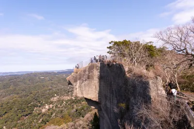
Partway up the trail, you’ll come to a lookout point where you can get some views of Tokyo city below.


Eventually, the trail links up with Trail 6, and so with the two trails merging, there were some more people about.


You’ll come to the final staircase before the summit.


The official course time lists this as a 100-minute climb, but I was a little fast today, so it only took me about an hour.

And from the summit, you can see Mt Fuji, if you are lucky. And I was pretty lucky today!


At the summit, you can get a hot bowl of soba if you are hungry - the inside of the shop is pretty tiny but you are allowed to take your bowl to one of outside tables in the area.


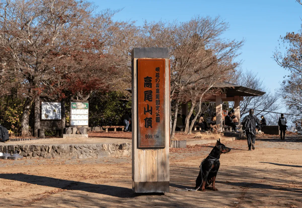
And then of course, you’ll want to get a photo with Mt Takao’s peak marker. Autumn is the most popular time to hike in Japan, so there were already plenty of people taking selfies with it. Expect to line up for quite a while if you come at a busier time (on the weekends or later in the day).

There was a girl with an eye-catchingly large doberman. Although it was really quite cute and would barely sit still long enough for her to take a photo of it together with the peak marker (it kept running back to her). I don’t see very many large dogs living in Tokyo, and if I do see one, it tends to be a labrador or border collie. I suppose if you lived near Mt Takao, which is sort of rural compared to inner-city Tokyo, you can afford a larger house and have the space for a larger breed.

From here, if you take a look at the trail map there are 5 possible routes you can descend via so it can make for a pretty tough choice. If you want to check out the Takaosan Temple though, you will have to descend via Trail 1.
(If you already came up via Trail 1, you might want to try descending via Trail 4, since you will pass a nice suspension bridge)

Even with the cable car, it’s a bit of a steep climb up some staircases to get to the temple and the summit, so I passed plenty of people huffing and puffing their way up (one lady unfortunately decided to give up on reaching the summit altogether). Although Mt Takao is such a beginner-friendly mountain, ironically it also is the mountain with the highest number of injuries per year in Japan (131 in 2024) just due to the sheer number of visitors it gets.

As you pass the temple buildings you will notice a pair of Tengu statues. The one on the right, a “Yamabushi tengu” has a long pointy nose, and is generally what comes to mind for me when I think of a Tengu.


The one on the left is a “Karasu tengu” with a crow’s beak on his face. I don’t see ones like this as often - actually I probably haven’t seen one outside of Mt Takao.


There was also quite a bit of a line for the wish-fulfilling ring, or “Negai Kanau Wa Kuguri”.

You’re supposed to head through the ring, and then hit the bell and make your wish.

As you head along the descent path you’ll also notice a long line of wooden panels. These are all companies or people who have donated to the Mt Takao temple.


Like in last week’s hike to Mt Oyama, Mt Takao has a set of onna-zaka and otoko-zaka (“woman’s climb” and “man’s climb”) trails - so the trail briefly splits, where you can take the stairs down the harder “man’s” path, or down a more gentle slope for the “woman’s” path.

While from my Western point-of-view I think the slope-naming traditions are a bit sexist in this day and age, I think it’s a long way down the list of things Japan could do to help improve its gender equality situation.
As a quick example, you might be surprised to know that Japan is the only country in the world where a couple must share a surname after marriage. Obviously this means the majority of women give up their surname. Even though we recently got our first female prime minister which you think would be a very exciting new development, she’s a very conservative one and is in favour of keeping the surname rule as-is, so unfortunately I don’t think that’s going to change anytime soon.

Anyway, back to the hiking! There were so many people about here, many of whom had probably gotten off the cable car.

Along the way you’ll pass a little seasonal decoration on a large tree stump. I’m not sure who does it, but it’s always being updated. Funnily, it’s even been featured on the news as “Mt Takao’s Banksy”, and is reportedly done by a local who hikes Mt Takao nearly every morning.

There’s a couple of other points of interest on Trail 1 - the tako-sugi or “octopus cedar”, which has been standing for over 400 years, plus a monkey zoo.

My other objective for today was to eat something tasty, so I kept my eyes peeled for Takao’s tengu-yaki, which are sold just behind the cable car building.


There were plenty of people lining up, but they were pumping them out speedily so the line moved quickly.

Freshly made, and only 250 yen - not bad.

From nearby you can see out towards the peak of Mt Jinba. If you’re looking for a harder-level course, you can do a traverse from Mt Jinba to Mt Takao, which takes about 6 hours.

Past the cable car station and the tengu-yaki, the rest of the descent is all along a road.

There’s not too much to see, although there is one detour you can take to get another view of Tokyo.


Done with my hike, I headed back towards the station. Everything was still closed when I had passed it in the morning, but they were all opening up now. Normally you might see some small local stores at a trailhead, but nothing too fancy.
However since Mt Takao is such a highly-visited location there is a Salomon store (a French hiking brand very popular in Japan) plus a couple of food options that wouldn’t look out of place if you had seen it on a street in the city.


It wasn’t even 11:30 when I finished with my hike, so I decided to find some coffee before heading home.

I never thought it would happen, but I managed to gain the ability to drink black coffee this year (yay) so I bought their pour-over coffee. Not bad.

I love coffee, so I have thoughts of starting some sort of review section on my blog (I like buying beans too), or at least some sort of “Emma’s recommended places” list. Maybe a project for next year.
Hiking course options
| Date climbed | Length | Course time |
|---|---|---|
| 2025-11-28 | 7.4km | 3h45min (the expected time for an average hiker without breaks) |
To figure out how you want to climb Mt Takao, you’ll want to take a look at their trail map. It can be a little bit overwhelming with the options, but if I were to list a couple of combinations:
- The shortest: take the chairlift and/or cable car in both directions, and walk the remainder of Trail 1 past the temple to the summit. The climb will take 50 minutes, and the descent 40 minutes for 90 minutes in total.
- A beginner-friendly hike: Take Trail 1 up the road, past the temple and to the summit. On the descent, start by going down via Trail 4, which takes you over a nice suspension bridge, before you join back up with Trail 1 partway down.
- Skip some of the crowds: Take either Trail 6 or the Inariyama trail up (Trail 6 has a waterfall so I might recommend that one) and then Trail 1 on the way down to see the temple.
- Skip all the crowds: Head up via Trail 6, and then descend via the Inariyama trail. Trail 6 is “climbing only” so you will need to climb via this one. The downside of this is you will miss out on all of the temple attractions, which is probably half the reason you’re coming to Mt Takao anyway.
Regardless of which combination you choose, you’ll only be looking at a 3 - 4 hour hike tops.
Public transport access
Mt Takao can be accessed via the Takaosanguchi (高尾山口) or “Mt Takao trailhead” train station on the Keio line. Make sure not to mix this up with Takao (高尾) station, which the previous train station.
Getting to Takaosanguchi station will take you around 55 minutes from Shinjuku station, or 80 minutes from Tokyo. The express trains are pretty frequent - every 10 minutes - so you can be pretty flexible on timings. If you are coming from somewhere else in Tokyo, you’ll need to transfer onto the Keio line at Shinjuku station.
The hike starts directly from the train station, so you don’t have to worry about buses, making it a very convenient hike.
My one pro-tip would be that if you are transferring from the JR line to the Keio line at Shinjuku station, make sure you head downstairs on the train platform. Shinjuku’s train platforms on the JR Line tend to have stairs heading up and downwards. It can be a bit of a maze, but heading downstairs and sticking in the station underground will make for a quicker transfer.
Car access details
There is some parking at Takaosanguchi station, but expect to pay up to 2000 yen for a day’s parking. Definitely one I’d recommend coming by public transport if you can.
When to hike Mt Takao
Due to its low elevation, Mt Takao can be hiked basically year-round without snow. Tokyo tends to get a couple of days of light snow a year, so if it snowed in Tokyo, you can expect there to be some snow on Mt Takao as well, but otherwise you should be fine.
However since it is so low elevation, and summers in Japan get really hot, I would try and aim for the spring / autumn seasons if you can. If you’re hoping to get a view of Mt Fuji, you should also target the colder months, as the chances of seeing Mt Fuji are much higher in winter.
Read more


Support me
📸 Thanks for reading! If you'd like to read more posts like this one, you can follow me on Instagram to stay up to date on my hiking adventures.
If you found this post useful, you can show your support by buying me a coffee - I write this blog for fun, but coffee is always appreciated! ☕
Recent posts
 hikes
hikesMt Nokogiri: a hike to Chiba's stone quarry
18 Mar hikes
hikesMt Miura-fuji and the Miura Kaigan Cherry Blossom Festival
9 Mar hikes
hikesAkabokko: hiking in Ome
16 Feb
Comments
Leave a comment