Hiking log
- Elevation 1963m
- When to climb Mid-June - Oct
- Out-and-back courses available from 2 trailheads (Amakazari-kogen and Amakazari-onsen), both are around 6-7km over 6.5 hours. You can also do a point-to-point hike between the two.
Mountain stats
A shuttle bus service for hikers runs from Itoigawa station to the Amakazari-onsen trailhead, making this possible as a day hike.
A more than 4 hour drive from Tokyo to the Amakazari-kogen trailhead, which is the closer of the two.
Mt Amakazari (雨飾山, amakazari-yama) is one of the four Hundred Famous Mountains of Japan located in Myoko-Togakushi Renzan National Park near Hakuba. The course is a litle steep, but the final 30 minutes to the peak include a ridgeline walk featuring lots of alpine flowers in summer with views out to the Sea of Japan so it’s well-worth the effort. Since it’s more than a 4-hour drive from Tokyo, my partner and I opted to turn this hike into a bit of a weekend camping roadtrip and slept the night before at the trailhead’s Amakazari-kogen campsite.

At a relatively low elevation of 1963m, I was a little hesitant to be climbing Mt Amakazari in the peak of summer, but as soon as you get off the highway and are driving through the valleys of Hakuba, you can already feel the drop in temperatures compared to the stifling heat of Tokyo. Since we set off in the morning to beat the traffic, we stopped off to do a bit of sightseeing at Hakuba’s Happo-Ike, before arriving at the Amakazari-kogen campground in the afternoon.

Since the campground sits at an elevation of 1000m, that night it was actually cold enough to need a jacket, which felt pretty unbelievable to me in summer (at least, while not being on top of a mountain). Since it was a Friday night, it was pretty quiet and there were only a few other groups camping.

In the morning I was a bit reluctant to get out of my cozy tent, but by about 5:30am we were up and hiking. The first 15 minutes of the trail is mostly flat as you walk along a marshy boardwalk.


There’s a portable toilet booth located less than 2 hours into the trail - which you’ll need to bring your own disposable toilet bag if you want to use. One of the vending machines at the trailhead stocks these, and there is a special bin to throw these out at the trailhead as well.

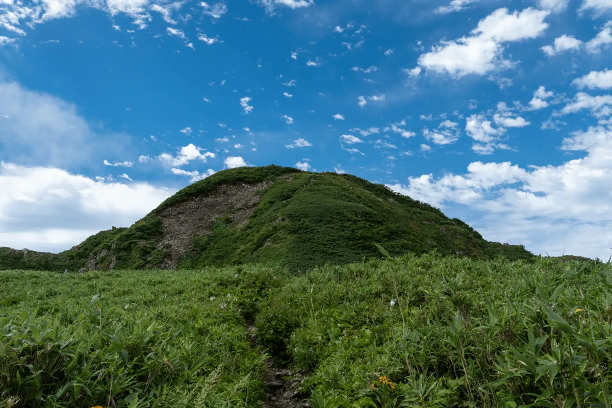
After about 80 minutes of hiking, your first view of the peak of Mt Amakazari comes into view!

The course takes you up the green mound third from the left, before you traverse across to the next hill, and then finally the pointy-looking peak of Mt Amakazari on the very left.
From here you’ll start to hear the rushing sounds of water as you have a short descent down to the Arasuge-sawa (荒菅沢). It’s a little stream you have to cross, but you can balance on some rocks so you don’t have to get your shoes wet.


It was a little bit after 7am here, and I knew the hike beyond this point was just one steep climb upwards, so we took a break here for some breakfast.

Although it had felt like we had had the forest mostly to ourselves on the hike up, there must have been quite a few hikers a close distance behind, because in our quick 10 minute break there was a steady stream of hikers who continued on ahead of us (who we mostly ended up overtaking again later!)

From here, the course does get a bit steeper and the terrain starts to become more rocky.

As you escape above the tree line, you can see out back towards what is probably the carpark where we started our hike.

I mentioned earlier on that Mt Amakazari itself is a rather pointy peak, and before that you have to traverse over two hills. The first of those becomes visible ahead of us.

It looks tantalisingly close, but you’ll have to do some clambering over rocks here, which slows you down a fair bit.


Once you make it up on the first hill, Sasa-daira (笹平), the final trail up to Mt Amakazari comes into view. It looks quite overgrown, but there is a well-carved trail here amongst the greenery.

There were so many butterflies, dragonflies, bees and other bugs up here too, plus a large variety of alpine flowers. When hiking in summer, my instincts have usually been to try and head as high-altitude as possible to escape the heat, and save mountains like Mt Amakazari for autumn when its a bit cooler. But I feel like early August turned out to be a pretty perfect time to visit this mountain.


And on your right, the Sea of Japan and the coastal town of Itoigawa come into view.

As we approached the peak, we could see plenty of people already up on the summit, as well as those making their final climb up. I got the impression that this was a pretty popular time to reach the summit.

And at around 9am, we reached the summit!


The peak is split into two sections - the actual peak marker, plus a separate viewpoint where you can see all the way out to the sea.


Today we could also see out to the North Alps of Japan.

The trail is an out-and-back, so you’ll head back the same way you came.

I didn’t realise it at the time, but after I got home and started writing this blog post, I found out that this trail is said to resemble a goddess’s face - can you see it?

The official time for this course is about 6.5 hours, but we took closer to 7.5 hours as we spent plenty of time taking photos of all the bugs flittering about near the summit. My partner got quite excited to see a lady beetle threesome, which I’ll spare you the photo of. We also spotted some Asian longhorn beetles, but I don’t want to give anyone a jump-scare so let’s just stick to the butterflies on this blog post!


Along the ridgeline there is also the turn-off point if you want to take the descent course down to the other trailhead.


If you use hiking poles, this rocky stretch between Sasa-daira and the stream crossing is probably where you will want to put either one or both of them away, as there’s enough clambering down over rocks that holding them in both hands will become a bit of a hindrance.


After finishing our hike, we stopped off at a local onsen, and then headed towards the town of Itoigawa to check out the sea and spend another night camping before heading home.


Hiking course options
| Date climbed | Length | Course time |
|---|---|---|
| 2025-08-09 | 7.5km | 6h20min (the expected time for an average hiker without breaks) |
Mt Amakazari has two trailheads, both of which offer out-and-back courses:
- The Amakazari-kogen (雨飾高原) trailhead (the one I used)
- The Amakazari-onsen (雨飾温泉) trailhead (also known as the Mt Amakazari trailhead)
Both courses are roughly the same distance (6 - 7km) and will take around 6.5 hours round trip. Of course you could also combine both trailheads to start at one and end at the other. I can’t comment on which trailhead is better, but it does seem like the Amakazari-kogen trailhead is a lot more popular when looking at YAMAP, and is closer if you are driving from Tokyo. But the Amakazari-onsen trailhead seems to have the better options public transport-wise.
In terms of accommodations, both trailheads do have a mountain hut:
- The Amakazari-Kogen trailhead has the Amakazari-sou (雨飾荘)
- The Amakazari-onsen trailhead has the Amakazari-sansou (雨飾山荘)
A digital map is also available here.
When to hike Mt Amakazari
Mt Amakazari can be hiked from mid-June until the end of October. It seems like there may still be snow in June and parts of July, especially on the stream-crossing bit if you are coming from the Amakazari-Kogen side. If you want to double-check the trail conditions before your hike, you can see the latest trail logs on YAMAP.
Public transport access
Amakazari-onsen trailhead
The Itoigawa Taxi company runs a “taxi” service (more like a shuttle bus) for hikers from Itoigawa station (糸魚川駅) for 2000 yen one-way which you can see the details of here. The first bus leaves at 7:10am, and will get you to the trailhead at 8am. The only return bus is at 16:10. Itoigawa station does have Shinkansen access, so you could arrive at the station the night before, book a hotel at the station and then hop on this bus in the morning.
You have exactly 8 hours to do a 6.5 hour course, so it should be fine if you are confident in your hiking abilities, and you’ll be able to stop by the Amakazari Sansou’s onsen if you have enough spare time as well.
The bus only runs on weekends and public holidays, and requires a reservation. If you’re coming on a weekday, the Amakazari Sanso website mentions other access options including a regular taxi (7000 yen), or a fairly unappealing option where you can get a local bus part of the way, and then walk 2 hours to the trailhead.
Amakazari-kogen trailhead
You can also use public transport to access the Amakazari-kogen trailhead. Access is via a bus from Minami-otari station (南小谷駅) and it will take 40 minutes to reach the Amakazari-kogen (雨飾高原) bus stop. Unfortunately the downside here is you have to walk the final 3km (40 minutes) from the bus stop to the trailhead itself. You should be able to find the latest bus timetable by Googling “小谷村営バス” or seeing the PDF for 2025 here.
If you are staying at the Amakazari-sou, the bus stop is only a 5 minute walk away, and they do provide a service where they will drive you to the trailhead, although you will have to make your own way back to the bus stop after your hike (which is fortunately all downhill).
Amakazari-kogen to Amakazari-onsen trailhead
If you really don’t want to spend the night in a hotel, I did find one example of a YAMAP activity where a hiker got on an overnight bus (probably from Tokyo), got off at Tsugaike Kogen (栂池高原) at 6am, and then transferred onto the 6:49am bus before arriving at Amakazari-Kogen at 8:11am. He then hiked through to the other trailhead, and got on the taxi at 16:10. You’d have 8 hours to do the 10km hike which is possibly doable if you are speedy enough.
Car access details

There are carparks at either trailhead:
- The Amakazari-kogen trailhead carpark. This has a main carpark at the campsite, and an overflow one a little bit down the road for a total of 90 cars. This one had a really clean washlet toilet thanks to the campsite.
- The Mt Amakazari trailhead carpark. Looking at Google, this one looks to be quite tiny, at a total size of 25 cars.
Mt Amakazari is most popular in the autumn foliage season, so expect the carpark to be quite crowded on the weekends during October, and you’ll probably need to park on the side of the road depending on what time you arrive.
We came at the beginning of August, and even though it was a Saturday, it looked like the carpark at the Amakazari-kogen didn’t fill up enough to warrant any cars parking on the side of the road.
Camping at Amakazari-Kogen
There is the Amakazari-kogen Camping Ground available at the kogen trailhead, where we spent the night. You have two options for staying here:
- Reserving a dedicated spot (online booking). Expect to pay up to 5500 yen for the camping spot itself, plus an additional 1100 per person. They have pricing tiers depending on the season, so it was a little cheaper on a Friday night at 4400 for the spot, but would still be an eye-watering 6600 yen total for the two of us. All the spots let you park your car next to your campsite. There is a hiker-specific booking category as well which is useful since you are allowed to leave your tent up until you get back from your hike, and then pack it away.
- Using the hiking “free site” (no booking allowed). This costs 1760 per person in the high season, and was 1540 yen per person on a Friday night - much cheaper! The downside is that this is just a small grassy field, so it’s first-come first-served. I suppose on a busy weekend you will have to get quite close with your neighbours, and I would expect that arriving too late in the day would not be a good idea. You can leave your tent put up until you get back from your hike.

When I first looked into booking last-minute, it seemed like the weekends do book out, although there was still bookings available for Friday nights. Factoring in the cost, we decided to just go with the free site. Since the campsite is right next to the carpark, we opted to set up our tent on the very right-hand side of the field furthest away from the carpark, since I saw some Google reviews mentioning that it can get a bit noisy with cars pulling in in the night. There were only 3 groups set-up on a Friday, so there was plenty of space.
The campsite does offer a shower and clothes drying service for a fee. The water next to the main building is drinkable, but the water down by the toilets at the carpark is not. There is no cell reception, but they do provide free Wi-Fi, and it seems like you can throw away rubbish during their staffed hours (9am to 5pm).
Onsens near Amakazari-Kogen
Yamada Ryokan
If you’re finishing your hike on the Amakazari-Kogen side, your main onsen option is the Yamada Ryokan (山田旅館) which is about a 15-minute drive down the road from the trailhead. The ryokan closes at 3pm, so you’ll need to finish your hike early if you want to stop by here afterwards.
Since getting to this ryokan requires a 30 minute drive up a windy rural road, I half-expected that only hikers would bother to stop by, but there were 2 other couples who had visited around the same time as us, and they didn’t seem to have come from the mountain. From overhearing the conversation of one of the couples, it seems like they stopped here specifically to check another onsen off of their list, so maybe this one is somewhat famous - it does have a history dating back to the Edo period. The ryokan’s website mentions that the author of the Hyakumeizan book Kyuya Fukuda himself also stayed here!
It also mentions that it was selected as one of four representatives of Japan’s hot springs at a hot springs exhibition held in Germany in 1881, which makes it sound rather impressive. I tried to Google to learn more about this fun fact - nothing popped up in English, and funnily enough it seems like if you Google for it in Japanese you’ll just stumble upon other Japanese people scouring archives and trying to figure out what the details of this exhibition actually was.

You can also choose to try a taste of the onsen water at a tap available outside of the building, which was a first for me. It tasted like iron (i.e. blood) so I would recommend being prepared to wash the taste down with something else afterwards.
Free outdoor onsen
For the more adventurous, there is a free outdoor onsen (with a donation box) next to the Amakazari-sou. From the Google reviews it seems like there are a lot of bugs about so I decided to give it a miss. This one is open until 9pm though.
As a side note, there is some outdated info available online about the onsen at the Amakazari-sou, which used to offer day-trip onsen use but no longer does.
Read more


Support me
📸 Thanks for reading! If you'd like to read more posts like this one, you can follow me on Instagram to stay up to date on my hiking adventures.
If you found this post useful, you can show your support by buying me a coffee - I write this blog for fun, but coffee is always appreciated! ☕
Recent posts
 hikes
hikesMt Nokogiri: a hike to Chiba's stone quarry
18 Mar hikes
hikesMt Miura-fuji and the Miura Kaigan Cherry Blossom Festival
9 Mar hikes
hikesAkabokko: hiking in Ome
16 Feb
Leave a comment