Hiking log
- Elevation 183m
- When to climb mid-February
- A 3-hour station-to-station hike.
Mountain stats
Your hike starts at Keikyu-Nagasawa station, an 80-minute trip from Tokyo.
Not recommended to come by car.
Mt Miura-fuji is a low-elevation mountain located in Yokosuka, Kanagawa. If you time your hike for mid-to-late February, you can also swing by the nearby Miura Kaigan Cherry Blossom Festival after your hike, making for a nice day out. The cherry blossoms that bloom here are an early-blooming variety known as the “Kawazu-zakura”. I actually think they’re prettier than the regular sakura you see in March - April, as they bloom a deeper pink colour.

A speedy express train out of Shinagawa will take you down the Miura Peninsula to Keikyu-Nagasawa station (京急長沢駅), where you begin your hike. The area is not too rural so there is a convenience store nearby if you want to load up on some snacks before you begin hiking.

The first bit of your hike is along a short stretch of road before you reach the trailhead. The start of the trail sort of feels like you’re heading into the jungle. We even spotted a bushy tail of what was possibly a squirrel (?!) but it scampered out of view before we could get a closer look.


The hike up to the first summit of Mt Miura-Fuji is quite quick, and we were there within 30 minutes. From here, it’s another 30 minutes to the second “peak”, Mt Houdai.


“Houdai” literally means “Artillery battery”, and so Mt Houdai (砲台山) is named after a hole in the ground where an anti-aircraft battery (gun) once stood in WW2. The first thing that comes to mind for me when I think of Yokosuka (where this hike is located) is its US Navy Base, but prior to WW2 and the US taking it over, it was actually the shipyard for Japan’s Navy as well.


With another 30 minutes of walking, you’ll reach the third and final peak for the hike - Mt Takeyama (武山). This peak comes with a small viewpoint deck with some nice views, plus a small shrine.


I saw some rustling in the trees so I headed over for a closer look - possibly to check out a bird - and to my surprise it was a squirrel!


Apparently these are Formosan squirrels - unfortunately considered a pest in Kanagawa Prefecture (and especially in Kamakura). This was my first time spotting though so I was pretty excited.
From here it’s only a descent remaining, as you follow the signs for the “Tsukuihama Tourist Farm”. There were plenty of squirrels rustling about, but they were all too speedy for me to get a good photo of.


You’ll eventually come down to a road, passing houses and a couple of farms.


The Tsukuihama Tourist Farm sells local vegetables, and offers strawberry-picking for about 2500 yen. They have quite a number of buildings, and had a crowd of non-hikers visiting - presumably maybe combining it with a visit to the nearby sakura festival.


Near the tourist farm, we also spotted our first blooming kawazu-zakura tree.


Past the Tourist Farm, you’ll mostly follow the river back to Tsukuihama station.


There are also lots of things growing!


Finishing your hike at Tsukuihama station, you’ll get on the train for one stop to Miurakaigan station.

As soon as you get off the train, you can see some sakura trees just outside the station exit, and there are plenty of people about. We came on the 28th of February, which was about 1 week past the “peak” viewing season. So you could see that some of the trees had started to lose their petals and turn green.

Near the station there is a market where you can buy some snacks and local goods, albeit it does look a little overpriced. There’s also a supermarket and convenience store nearby if you are looking for lunch. From here, you’ll want to follow the steady stream of people in the direction of the train tracks (in the same direction the train you got off was heading).

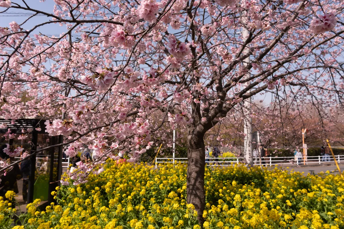
It’s about a 1km of walking before you reach the main stretch of kawazu cherry blossom trees. Directly underneath the trees are yellow rapeseed blossoms (or “nanohana”). Which makes for an especially nice contrast. Doubly so if you can find a good spot to combine that with the bright red train of the Keikyu line train.


Eventually you’ll come to a small park on your left - this is a good spot for a picnic if you’re hungry. There was also one big tree here which was probably the prettiest out of all the ones I had seen, so a good spot for lots of photos.

After lunch, we headed across the road to the small Komatsugaike Pond. The trees along the water here are also kawazu-sakura trees, so you can get a really pretty photo of them reflected in the lake of the pond. Unfortunately it seems like they had nearly lost of all their petals at this point though.

Also quite unexpectedly, there was a Great cormorant on the stairs who seemed super chill, and didn’t care at all about all the people milling about. The nearby stall owners seemed quite amused by his presence and kept beckoning him over - seemed like he was a regular there.


There’s some more food stalls here - and they tended to be more traditional and cheaper festival fare than what you get right by the station, so if you were going to get a snack, I would recommend here instead (just remember to bring cash).


Passing the lake, you’ll head back up to the road to begin your walk back to the station. Along the way you’ll pass by some more farms.


There’s even the option to do a “pull your own daikon” experience, which some young guys were quite pleased about.

And then it’s a final walk back along the stretch of sakura tree-lined road back to the station. If you are patient, maybe you could try and get a better photo of the train.


All-in-all, this is a great beginner-friendly hike, especially if you can you time to perfectly with the cherry blossom festival. This is one of the major spots for the Kawazu-zakura - another spot that comes to mind is the town of Kawazu, which is where the this variety actually originated, but that one is a 3 - 4 hour trip from Tokyo so a little bit less accessible as a day trip.
When to come see the Kawazu Cherry Blossoms
The best time to come see the Kawazu Cherry blossoms is mid-February to early March. Usually there is a day that is considered the actual “peak” date, and this year was around the weekend of the 21st of February. There is also a public holiday on the 23rd of February, which depending on the year is a 3-day weekend (this year it was on a Monday) so you can expect that date/weekend to get pretty busy.
This year, we did the hike on the 28th, so I was expecting it might be less crowded - but even so it was pretty busy. If you want some nice photos, it may be worth coming on a weekday.
It can be a little hard to time the “full” bloom, but I think even if you come a week late or a week early, there’s still plenty of opportunity to see at least some of the trees blooming, since they seem to bloom at slightly different times.
The blooming time can change year-on-year, and e.g. if it rains then it can make the flower petals shed early, so if you want to get super-specific you should google “三浦海岸 河津桜 見頃” (or “Miura-kaigan Kawazu-zakura best time to see”) and there should be a couple of sites that provide an estimate of the peak bloom time.
When to hike Mt Miura-fuji
Mt Miura-fuji is such a low elevation mountain - with a max elevation of 200m on the entire course - that I would really strongly recommend visiting this one in the winter months if you can. But technically you can hike it year-round.
Hiking course options
| Date climbed | Length | Course time |
|---|---|---|
| 2026-02-28 | 7km | 3h (the expected time for an average hiker without breaks) |
The hiking course that I took is an under 3 hour hike starting at Keikyu-Nagasawa station (京急長沢駅) and ending at Tsuikuihama station (津久井浜駅).
You can do it in the other direction as well, but I would hike it in the direction I’ve hiked, as this means you can make a stop off at the tourist farm at the end, and pick up some veg if you want.
The other alternative might be to try and do the festival first, to beat the crowds. The one downside of that is doing the festival last lets you have a picnic or pick up some snacks after you’ve finished your hike, and I tend to be hungry!
Public transport access with itinerary
The hike starts at Keikyu-Nagasawa station (京急長沢駅). If you’re coming from Tokyo, it’s an 80-minute journey from Tokyo station, with a transfer onto the Keikyu line at Yokohama station.
Depending on where you are coming from though, you might transfer on earlier on the line at Shinagawa station - this is great as its the first stop on the line, so you are guaranteed a seat, and the train line has forward-facing seats so it’s quite comfy.
The hike finishes at Tsuikuihama station (津久井浜駅). From there you can get back on the train to go one more station to Miura-Kaigan station (三浦海岸駅). All trains will stop at that station so you can hop on the express train no problem.
Car access details
I wouldn’t recommend hiking this one by car. Although if you have a dog - I did see at least two doggies on the course so maybe as a local you can do some sort of loop variation as well.
Read more


Support me
📸 Thanks for reading! If you'd like to read more posts like this one, you can follow me on Instagram to stay up to date on my hiking adventures.
If you found this post useful, you can show your support by buying me a coffee - I write this blog for fun, but coffee is always appreciated! ☕
Recent posts
 hikes
hikesAkabokko: hiking in Ome
16 Feb hikes
hikesMt Jinba to Mt Takao traverse hike
28 Jan hikes
hikesMt Nabewari: a hike to eat its famous Nabeyaki Udon
26 Dec 2025
Leave a comment