Hiking log
- Elevation 1354m
- When to climb March - Jan
- 1.6km out-and-back course taking only an hour.
Mountain stats
Public transport access is technically possible but not recommended. It will require a 3.5km walk from bus stop to trailhead.
2 hour drive from Tokyo to Panorama-dai carpark.
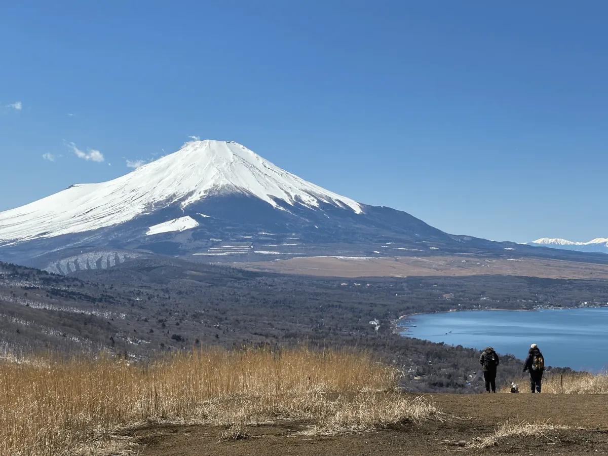
Myojinyama (明神山, Myojin-yama) is mountain to the east of Lake Yamanakako which comes with an absolutely gorgeous view of Mt Fuji. It’s only 1.6km to the summit, so it’s perfect if you want somewhere quiet to enjoy the view of Mt Fuji but that doesn’t take too much effort to get to. It’s been my favourite view of Mt Fuji this year so far!
I climbed it as part of my goal to climb all mountains in the 36 views of Mt Fuji series. Since it’s such a short hike, I climbed Mt Ashiwada in the morning before making the less than 1 hour drive over to Lake Yamanakako to climb Myojinyama.


The trail is basically one steep walk up a large hill. In parts the path was almost like a narrow trench, so it wasn’t the easiest to walk through.
On the way back down I realised there were actually other pathways alternate to the trench, but these are kind of hard to spot on the way up.
There’s not too much to see at the summit, other than a little shrine.

However it’s when you start to descend where the real fun begins! Because you get to spend the entirity of it staring at Mt Fuji, and it’s a really beautiful view.


I think what really made this a great view for me was the contrast between the lake, the yellow grassland and the snow-covered peak of Mt Fuij.
Even from the carpark you can get great views of Mt Fuji, but it’s not quite the same.


Honestly I wouldn’t have climbed this mountain but for the 36 views of Fuji challenge, but I’m really glad I did! It was definitely worth it.
Hiking course details
| Date climbed | Length | Course time |
|---|---|---|
| 2024-03-22 | 1.6km | 1h5min (the expected time for an average hiker without breaks) |
This is a out-and-back course beginning and ending at the Lake Yamanakako Panorama-dai lookout. There are toilets available at the carpark.
Car access details
| Car park | Time (from Tokyo) | Round trip cost |
|---|---|---|
| Yamanakako Panorama-dai carpark (山中湖パノラマ台) | 2h | ~6800 yen |
The viewpoint carpark is quite small. There were a couple of hikers, but the carpark was mostly just used by people coming to take in the scenery from the viewpoint at the carpark. So I think even if the carpark is full, if you wait a little bit a spot should free up.
Public transport access
This mountain is hypothetically accessible via public transport, but I’m not sure that I would recommend it. It involves:
- Getting a highway bus from Shinjuku to somewhere around the Lake Yamanakako area
- Getting off, transferring to a local bus and going to the 三国山ハイキングコース入口 (Mt Mikuni hiking course trailhead) bus stop
- Walking 3.5km (45 minutes) to the Panorama-dai car park.
I think the walking effort is not worth it. If you’re looking for another mountain in the Lake Yamanakako area I would recommend Mt Ishiwari instead.
Read more


Support me
📸 Thanks for reading! If you'd like to read more posts like this one, you can follow me on Instagram to stay up to date on my hiking adventures.
If you found this post useful, you can show your support by buying me a coffee - I write this blog for fun, but coffee is always appreciated! ☕
Recent posts
 hikes
hikesMt Nokogiri: a hike to Chiba's stone quarry
18 Mar hikes
hikesMt Miura-fuji and the Miura Kaigan Cherry Blossom Festival
9 Mar hikes
hikesAkabokko: hiking in Ome
16 Feb
Comments
Leave a comment