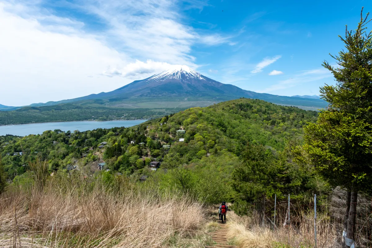
Mt Ishiwari (石割山, Ishiwari-yama) is a mountain right next to Lake Yamanaka-ko, and its close proximity to Mt Fuji makes for some excellent scenery if the weather is in your favour. With good public transport access via a direct bus from Shinjuku to the trailhead, Mt Ishiwari has a number of course options ranging from 4km to 10km, depending on if you want to extend your hike to visit the neighbouring Mt Hirao and Mt Ohira.
I’ve hiked Mt Ishiwari three times now. The first two times were via public transport, and so I was able to take the point-to-point course and finish at a separate bus stop. Unfortunately I couldn’t get a clear view of Mt Fuji on either one! My most recent hike was by car, so we started and ended at the Ishiwari Jinja carpark - and I finally got these amazing Fuji views (third time’s the charm).
Hiking Mt Ishiwari: a quick summary
2.5hr highway bus from Shinjuku (バスタ新宿) to Yamanaka-ko Hirano (山中湖平野) bus stop.
- Ishiwari Shrine LoopeasyHighway bus2.5 hrs·4.2 km·↑ 440m
- Mt Ishiwari to Mt Ohira traversemediumHighway bus5.5 hrs·11.4 km·↑ 760m
Starting at the Ishiwari Shrine trailhead
My most recent hike was via car, so we got the luxury of starting directly at the Ishiwari Shrine trailhead. If coming via bus - you’ll need to walk an extra 25 minutes from the bus stop to get here.
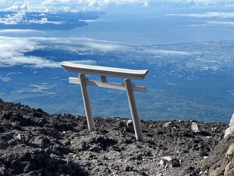
The torii gate at the start of the trail had gotten a nice new coat of paint since the last time I visited.


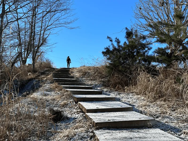
The very first hurdle you’ll face on this course is a very long, soul-crushing staircase. I couldn’t keep track, but apparently it has 403 stone steps in total. This is probably the toughest part of the course, and the stairs seem to go on for longer than you would expect.


Once past the stairs you’ll get to enjoy a bit of a flat stretch before you arrive at Ishiwari Shrine. From the torii gate, expect the total climb to take about 60 minutes to here.


Ishiwari Shrine is the mountain’s namesake. It features a large rock split in two - hence the name ishi-wari which literally means “rock breaking”.
For those who aren’t too tired out from the stairs, it’s said that if you do three loops around the shrine and pass through this split rock, good fortune will come your way, and your wishes will be granted. Back in 2024 I did the 3 loops and prayed for a good hiking year without any injuries - I think it worked! This time I was a bit too lazy though and just did one loop.

Make sure to take off your backpack though, as it’s impossible to pass through with it on (you’ll have to go sideways).

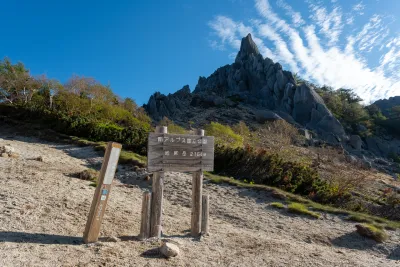
Reaching Mt Ishiwari
From the shrine it’s a further 30 minute climb to the summit of Mt Ishiwari, where you’ll be rewarded with a pretty decent Mt Fuji view if the weather is in your favour.

Mt Ishiwari is marked as one of the Hundred Famous Mountains of Yamanashi and so there is a wooden peak marker here that is available at each of the 100 peaks.
From here you can head back down to the trailhead if you just wanted a quick hike. Otherwise you can continue on to Mt Hirao and optionally Mt Ohira as well - the benefit of this is the trail continues to head towards Mt Fuji so you are going to enjoy an even better view.

The initial descent off Mt Ishiwari is the only difficult part of the course. It’s a rather steep dirt slope that may be muddy if it’s been raining recently. Luckily there is a rope most of the way down, so you just have to hold onto it as you descend. It may be helpful to have gloves to prevent rope burn, and/or some wet wipes as your hands may get a bit dirty.

As you continue your descent you’ll be able to see a small peak in front of you - I think that’s Mt Hirao - you can already see that you’re going to be able to get a better view from there!

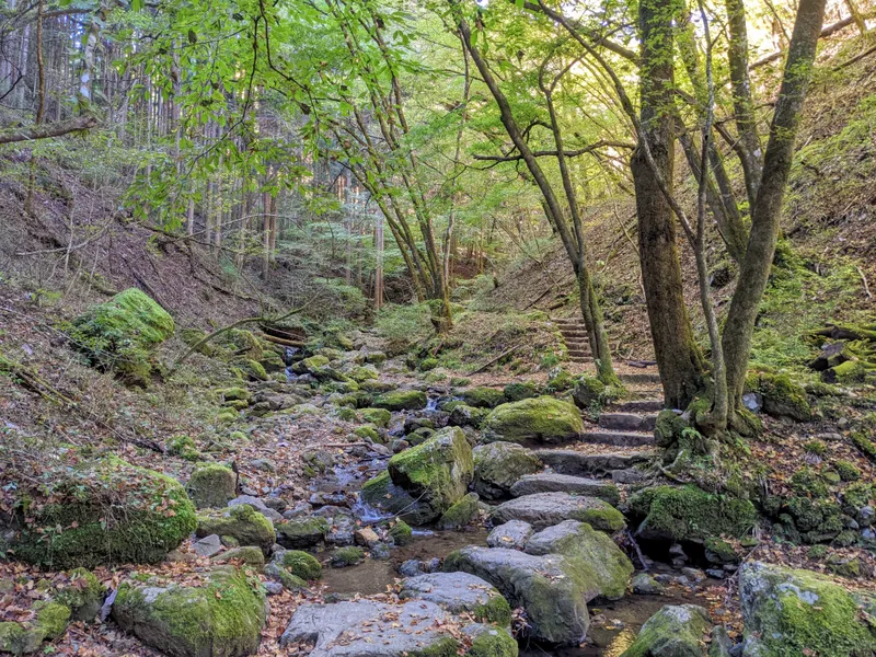
Beyond the steep descent there are some flat sections of the trail, and even a section that was rather overgrown as well.

Before the final short climb up to Mt Hirao, you’ll pass a junction point.

If you are planning on doing a loop hike, make a note of here as this is the point where you’ll make your descent back to the trailhead (luckily you don’t need to re-climb up that muddy, steep slope).
Reaching Mt Hirao
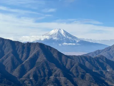
Eventually after a bit of a climb, you’ll make it to Mt Hirao - and an even better Mt Fuji view!

From here we continued along down a long staircase, heading towards Mt Ohira.


From here there’s a series of ups-and-downs.

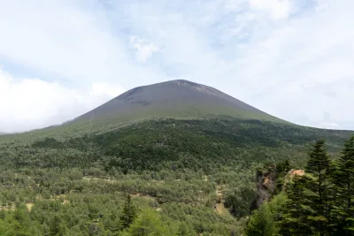
For a while Mt Ohira will block the view of Mt Fuji in front of you, but I find that only being able to see the tiny tip of its peak to be rather cute.


And after one final long, long staircase - you get to see Mt Fuji again!

Reaching Mt Ohira
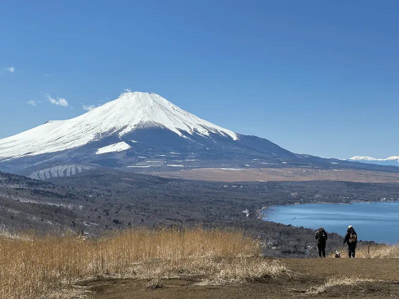
From the peak of Mt Ohira, you will get the best views of Mt Fuji from this entire hike. Expect it to take a total of 90 minutes to get here from the peak of Mt Ishiwari, or about 40 minutes from the peak of Mt Hirao.

I was super stoked with these views - the last time I hiked here, the peak had been obscured in clouds.

At the peak here there’s a couple of benches and a small shelter so you can take a break from the sun if it’s hot.

And on the right, you can also get distant views out to the snow-covered peaks of the Southern Alps, like Mt Kita and Mt Aino.


If you are planning on doing the traverse hike, from here you’ll continue onwards.

You’ll descend down a forested stretch, before finishing off your hike on a long concrete road back towards Lake Yamanaka-ko.

Since we came back via car though, we retraced our steps back up to the peak of Mt Hirao.

Along the way I was keeping my eyes peeled for a rather cutely named minor peak called “Imo-yama” (or Mt Potato) since we had missed the peak marker when we first passed by here. At first all we could see was this piece of tape wrapped around a tree - someone had written with sharpie on it.

And then we spotted this sign!

You can see the little McDonald’s potato fries - I thought it was rather cute. I wasn’t able to find any information online about how this ended up here. I suppose someone possibly decided to make and hang up this sign for the fun of it.


After the final climb back up Mt Hirao, we took in one last view of Mt Fuji and then began our descent back to the carpark.


It may come in handy to have a GPS app here - there were a couple points where we almost continued straight on, but we needed to take the left path to make sure we made it back to the carpark.

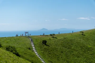
Enjoying the views at Lake Yamanakako

Once back at the carpark, we decided to have a quick drive along the lake to the Nagaike Water Park where we could park the car and get some nice lake views. There was a huge white swan boat in the distance as well.

Meeting the swans at Lake Yamanaka-ko
Speaking of white swans, when I hiked this back in January of 2024, we also finished our hike near the lake (at another point a bit further along). Coincidentally at the time there were two photographers who were feeding the swans (with bird pellets). The pair seemed quite knowledgeable about the birds and the swans seemed very used to humans - I managed to get some nice close-up photos.


I’m unsure if it’s exactly the same spot, but it seems like in more recent times some enterprising individuals have decided to actually block off access to part of the beach and sell swan food to tourists. I doubt this is legal.
From Lake Yamanaka-ko, you can find a couple of restaurants in the area if you’re looking for dinner. Otherwise there is the Benifuji no Yu onsen nearby as well if you have some spare time before the next bus back to Shinjuku.
Hiking course options
Slightly shorter than the hike I detailed in this post would be to do a loop only around Mt Ishiwari and Mt Hirao, starting and ending at the Ishiwari Shrine carpark (石割山神社駐車場).
To make your hike even shorter, you can just climb up to Mt Ishiwari and then retrace your steps back to the trailhead, but extending your hike to Mt Hirao gives you a better view.
In terms of difficulty, the trail up to Mt Ishiwari and back again is the easiest, albeit with a long staircase. The one thing you have to watch out for on the hike onwards to Mt Hirao is the steep dirt slope which you’ll have to descend with the help of a rope.
Note that if you are coming via bus, you will need to add an extra 1.7km (25mins) walk one-way to get to the trailhead from the Yamanaka-ko Hirano (山中湖平野) bus stop, which makes this loop hike 7.6km over 3.5 hours.
There is a toilet available near the bus stop, as well as at the start of the trail.
A point-to-point hike - the total distance accounts for the walk from the bus stop. Starting at the Yamanaka-ko Hirano (山中湖平野) bus stop, you’ll head to the Ishiwari Shrine trailhead, climb up to Mt Ishiwari, traverse to Mt Hirao and Mt Ohira and then descend down to the lake.
As you start and end at different locations, this hike is best done by public transport.
Similar to the traverse hike, this hike takes you from the shrine up to Mt Ishiwari, Mt Hirao and Mt Ohira. From there you will trace your steps back to Mt Hirao, and then take a separate descent path back down to the Ishiwari shrine carpark.
As it’s a loop hike, it’s the best option if you are coming by car.
Public transport access
Mt Ishiwari can be accessed directly via a highway bus from Shinjuku. You will need to book your bus in advance via highwaybus.com. For weekends I recommend doing this a week or more in advance if you can, as the first bus departing from Shinjuku tends to become fully booked out the closer you get to the date.
In terms of bus timings, the earliest you will be able to reasonably get to the Lake is just after 10am:
| Time | Location | Transport | Cost | |
|---|---|---|---|---|
| 07:45 | Busta Shinjuku (バスタ新宿) | Highway bus | 2350 | |
| 10:09 | Yamanaka-ko Hirano (山中湖平野) |
The bus terminal (or Busta) at Shinjuku station is accessible via its South Exit. It can be a little hard to find if you’ve never been there before, and it’s also on the third floor of the building. So I would make sure to plan in enough time between getting off the train and transferring to the bus terminal.
Once you get off the bus at Yamanaka-ko Hirano (山中湖平野), the timings schedule will give you 6.5 hours to do your hike, which should be enough time if you are an average-pace hiker, with maybe the option to squeeze in an onsen visit as well.
With the traverse hike, you will finish your hike at a different point on the lake. The nearest bus stop will be Fuji-san Yamanaka-ko (富士山山中湖), where you can get a highway bus back to Shinjuku. Alternatively if you did the loop hike, you can go back to the same Yamanaka-ko Hirano bus stop.
Generally I would recommend booking the return bus tickets in advance if you can. If you want to stay more flexible, you can reserve tickets online from your phone after you finish your hike. I think also you can get on the bus without a ticket, if they happen to have seats available (but I’m not sure how popular this route gets).
Alternatively, you can get a local bus back to Kawaguchiko station, and then get on a train back to Shinjuku from there.
Unfortunately due to the tourism around Kawaguchi-ko, the buses can become a little bit delayed with traffic so I would keep this in mind if you had plans afterwards.
Sample itinerary:
| Time | Location | Transport | Cost | |
|---|---|---|---|---|
| 16:55 | Fuji-san Yamanaka-ko (富士山山中湖) | Highway Bus | 2300 | |
| 19:10 | Busta Shinjuku (バスタ新宿) | |||
| Trip total: | 5070 |
Car access details
The main trailhead is at the Ishiwari Shrine carpark (石割山神社駐車場), which is a free carpark. The carpark itself is on the small side - when we arrived at 9am on a weekend, all the spots were already full. However cars tend to also park on the sides of the road, so we were able to snag a spot as well.

If the carpark is absolutely overflowing, the backup option is a tourist spot called the Yamanakako Kirara - it’s about a 30 minute walk away from the trailhead. It opens at 9am and parking costs 300 yen for the day.
By the time we finished our hike around 12 or 1pm, the carpark was nearly empty, so it seems most hikers must have quite a fast start (to make sure they can snag a car spot).

So an alternate strategy, if you arrive a bit later, may be to wait for one of the early hikers to make their return, and then take their spot.
When to hike Mt Ishiwari
Since one of the main drawcards of Mt Ishiwari is the chance to see Mt Fuji, I would recommend climbing it in the colder months (October through to January), when your chances of seeing Mt Fuji increase. You can check the SeeMtFuji website to see latest visibility forecast which I find to be quite accurate.
There may be snow on the mountain in winter (especially in February), so if you don’t want to hike in snow, I recommend waiting until March or April for your hike.
You can continue to hike Mt Ishiwari for the rest of the year, although in summer your chances of seeing Mt Fuji decrease by quite a bit, and it will also get quite hot.
As well as hiking Mt Ishiwari in mid-January, I’ve also climbed it twice in May, which was quite pleasant weather - although your odds of seeing Mt Fuji may be lower.
I would also recommend checking YAMAP to see the latest conditions before you climb.

Read more
See other hikes nearby

Leave a comment