Hiking log
- Elevation 2967m
- When to climb July - October
- Standard course is a 7.5-hour, 8.7km loop from Kitasawa Pass. There's also a 2-day course option starting from Ojiragawa-keikoku.
Mountain stats
Take a bus from Chino station to Todai Park, then shuttle bus to trailhead. Total travel time from Tokyo is approximately 4 - 5 hours. Due to the timings, expect to spend a night in the area.
Park at Todai Park carpark (1000 yen), then take shuttle bus to the Kitasawa Pass trailhead.
Mt Kaikoma (甲斐駒ヶ岳, kaikoma-ga-take) is one of Japan’s Hundred Famous Mountains located in the Southern Alps. Mt Kaikoma sits next to Mt Senjo, and the two have a bit of a unique setup. Both have their hiking trails start at the same point, only heading in different directions, and are both doable as day hikes. For that reason, I chose to do both Mt Senjo and Mt Kaikoma over 2 days, with a stay in between at the Komorebi Hut.
The trail up Mt Kaikoma is a tiny bit longer, and slightly less straightforward than Mt Senjo, so I decided to do this hike on the second day, when I would be able to have an earlier start in the morning. I started hiking at 5am, and since it was mid-October it was still completely dark.

Although I’ve done a couple of before-dawn starts before, they’ve always been together with a friend (other than Mt Fuji) so I did have a bit of nerves as I started this hike. Even more spookily, I noticed two sets of glowing eyes off the side of the trail, but luckily upon closer inspection these turned out to be 2 deer (who probably didn’t appreciate me shining my headlamp on them).

I breathed a sigh of relief once the sky started to grow lighter, and I passed a couple of people on the trail heading in the same direction as me.


The first stretch of trail is through the forest, with not too much elevation gain.


About an hour into the hike I passed a huge rock field, which luckily you don’t have to climb but the trail takes you on a path adjacent to it.

This course is a loop, which I did in a counter-clockwise direction at the recommendation of the hut staff the night before. This meant I got to enjoy the glow of the rising sun against the mountain peak, which was super pretty!


At the end of the rock field you’ll come to Sensui Pass (仙水峠). From here begins a steep climb up. Along the way you should be able to spot the peak of Mt Kaikoma - but it was unexpectedly quite a foggy morning so all I could see was the peak of Marishiten (摩利支天) which is a smaller peak that juts out next to the peak of Kaikoma itself.


As I began climbing I could see out to another peak in the opposite direction. I kind of just assumed that this was Mt Senjo, considering that is the main big mountain in the area.

But actually I was mistaken. I think it may be Mt Kurisawa (栗沢山) instead. Mt Senjo is actually way more to the right of it, and is visible at the end of a valley - but due to the fog it was partially obscured, so I only realised it was Mt Senjo after looking back at the photos later.

The hut staff had told us we would have perfect weather with no clouds this morning, and that’s what the weather forecast had been predicting as well, so the amount of fog was quite unexpected. I did manage to get a glimpse of the peak of Mt Kaikoma, though.

Before the main peak of Mt Kaikoma, you’ll come to the minor peak of Mt Komatsumine (駒津峰). It was 7:30am by this point, so I decided to stop for a quick breakfast break.

I got the hut’s breakfast bento, which turned out to be some inari-sushi.

When staying at mountain huts, you can opt for a hot breakfast, but usually I skip it since I don’t have too much of an appetite when I first wake up. There does tend to be a fairly wide range on what comes in a breakfast bento so it’s a bit of a surprise what you’ll get. This one was more on the simpler side (the nicer ones tend to have rice with a side of salmon, some pickles, etc).

From Mt Komatsumine, it was time to make the final, foggy approach to Mt Kaikoma. The trail is a little bit harder than Mt Senjo, and features a rocky section or two with chains, but nothing too difficult.


There are two routes up to Mt Kaikoma. There is a standard hiking path along its sandy slope, as well as a more rocky “variation route” which is marked via dotted lines on the YAMAP app. Usually I would skip anything that isn’t the official path (and that I didn’t have much info on) but the hut staff the night before had explained that this one wasn’t too difficult, so I decided to give it a go.


I’d say it was not too bad - there was maybe one rock that was a bit hard to haul yourself over, but nothing too difficult or steep. I would give it a go as long as the rocks aren’t slippery from rain.

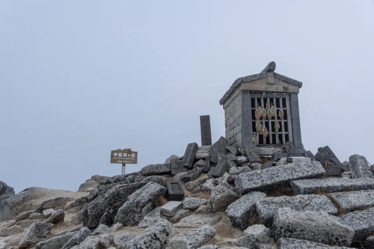
Around 8:45am, I made it to the peak of Mt Kaikoma. If you come from the variation route side, the peak marker will mark here as Mt Higashi-komagatake - this is the unofficial name favoured by locals living in the nearby city of Ina.

You only have to walk around to the other side of it if you want to get your photo with the official name of Mt Kaikomagatake. It seems like this sign is very new, and replaced an older wooden one only just last year in 2024.

The winds up here were pretty strong, but there were a couple of us loitering about in the hopes that the fog might clear to give us better views from the summit.

We didn’t have too much luck though, so after a quick snack break I decided to begin my descent.

Mt Kaikoma is quite unique among the hyakumeizan for how sandy it is. It reminded me of Mt Hinata, which is a smaller peak that is also famous for its sand.


Maybe it was due to the fog, but I managed to get a little bit off-course at some point and ended up following some person’s footsteps down the sandy slope which wasn’t quite the actual trail. I saw a guy hiking upwards who saw me and got a bit confused as to whether he was on the right path or not so I made sure to gesture to not come in my direction.

You’ll remember that next to Mt Kaikoma is a second, smaller peak called Marishiten (摩利支天), which is about a 30-minute detour from the main hiking course. I did the math on the return bus times and figured I had enough time to make a quick trip out to it.

I’m not exactly sure on the naming history of this summit, but it shares its name with a Buddhist deity. Actually if you google this peak’s name, all that comes up is her picture.

There was quite a number of objects scattered about this peak, so I would definitely say it’s had some religious significance at some point or other.


And from Marishiten, I got a clearer view of the peak of Mt Kaikoma!


Once back on the main trail, it was back towards Mt Komatsumine.


From Mt Komatsumine, it suddenly started to sprinkle down with rain (which was also sort of frozen). Totally unexpected since the weather forecast had been a 0% chance of rain, but I decided to pick up the pace until I could get into the treeline.

There’s one final peak to tackle, which is Mt Futago (双児山).


I reached the peak of Mt Futago around 11am. I had 2 hours until the next bus at 1pm, so I was making good time.


I made it back to the Kitasawa Pass bus stop around 12:15pm. I had left some of my gear (snacks, sleeping clothes) at the Komorebi hut where I had spent the night prior, so I took advantage of the spare time to change out of my hiking gear into some slightly more comfy clothes before I got on the bus back to the carpark.
Hiking course options
| Date climbed | Length | Course time |
|---|---|---|
| 2025-10-24 | 8.7km | 7.5hr (the expected time for an average hiker without breaks) |
The course I took is the standard day hike course you can use to climb Mt Kaikoma from the Kitasawa Pass (北沢峠) trailhead. I did the course in a counter-clockwise direction, which means you go via the Sensui Pass (仙水) on the way up, and then via Mt Futago (双児山) on the way down. You can do this in either direction, though.
As you approach the summit, there is a “variation route” you can take that’s a tiny bit more advanced than the main trail but it’s really fairly doable and not scary at all. But of course you can skip this and take the main hiking route.
There is also the option to do a 30-minute detour to Marishiten, which gives you some nice views of Mt Kaikoma.
If you’re tossing up whether to do Mt Senjo or Mt Kaikoma as a day hike, I would say that both are great mountains! If you’re concerned about the timings of a day hike, I would recommend Mt Senjo as its trail is 30 minutes shorter and does feel a bit more straightforward (little to no rock scrambling).
If you’re looking for a longer hike, Mt Kaikoma also has a 2-day hiking course as an option. This starts at the Mt Kaikoma trailhead (甲斐駒ヶ岳登山口) / Ojiragawa-keikoku carpark (尾白川渓谷駐車場) and goes via the Kuroto-one (黒戸尾根). You can view the trail for that one on YAMAP and there’s an English write-up for it here.
When to hike Mt Kaikoma
The main hiking season for Mt Kaikoma is between July and October. The buses do start running in mid-June, but there still will probably be some snow left at that time, and it may begin to fall in the later parts of October as well.
Note also that the buses only run from mid-June to mid-November, so you will only be able to do the hike from Kitasawa Pass during this time. Outside of that timeframe (and if you don’t mind snow-hiking) you will have to do the course via the Kuroto-one.
It seems that the buses also stop running once the area has its first snow - e.g. the 2025 bus timetable was schedule to run the buses until mid-November, but they ceased operation on the 3rd of November instead. As this YAMAP activity notes, if there is unexpected snowfall the bus may attempt to take you to the trailhead, but have to turn back mid-way so keep this in mind as well if you are planning on hiking towards the end of the season.
Public transport access
To access the Kitasawa Pass, you will need to take a shuttle bus from Todai Park (戸台パーク), which I have done a write-up for on my previous blog post about Mt Senjo. And similar to Mt Senjo, you can get a bus from Chino station (茅野駅) that departs once a day at 10:40am. If you are coming by public transport, the hike won’t be possible as a day trip as you will need to spend one night either at a campground or mountain hut before beginning your hike on day 2.
If you are coming by car, the first viable bus you can get back is at 1pm (the one before that was too early, at 10am).
If you are coming by public transport, the return bus to Chino station isn’t until 5pm, so you can get either the 3pm or 4pm return buses.
You can check out the 2025 timetable to get a rough idea of the bus timings. Once the 2026 timetable comes out, you’ll want to search for it on Google via a search term like “戸台パーク(仙流荘) → 北沢峠”.
Car access details
The Todai Park carpark costs 1000 yen for up to 5 days, which you will pay when you leave the carpark.
If you are attempting Mt Kaikoma during its peak season (summer, on the weekends), I would recommend arriving early and sleeping in your car to make sure that you can get a spot.

Read more


Support me
📸 Thanks for reading! If you'd like to read more posts like this one, you can follow me on Instagram to stay up to date on my hiking adventures.
If you found this post useful, you can show your support by buying me a coffee - I write this blog for fun, but coffee is always appreciated! ☕
Recent posts
 hikes
hikesMt Nokogiri: a hike to Chiba's stone quarry
18 Mar hikes
hikesMt Miura-fuji and the Miura Kaigan Cherry Blossom Festival
9 Mar hikes
hikesAkabokko: hiking in Ome
16 Feb
Comments
Leave a comment