Hiking log
- Elevation 1272m
- When to climb April - May, October - January
- A 16km, 7.5 hour out-and-back course, with the option to do a slightly longer 8 - 9 hour loop course.
Mountain stats
2 hours from Tokyo. Take the Odakyu line to Shibusawa station, then a 15min local bus to the Okura trailhead.
There are car parks at the trailheads, but with Tanzawa's popularity, I recommend taking public transport so you don't have to deal with finding a spot.
Mt Nabewari (鍋割山, nabewari-yama) is one of the peaks in Kanagawa prefecture’s Tanzawa mountain range. Its distinguishing feature is the bowl of nabeyaki udon sold at the summit’s mountain hut. While any meal tastes good when hiking, especially a hot one in winter, the nabeyaki udon is genuinely really good and would totally be something I would buy even if I was out on a regular day in the city. It had been two years since I last climbed Mt Nabewari, so I decided to make it my final hike for the year and enjoy a bowl of udon at the summit.
The hike starts at Okura trailhead, which you may be familiar with if you’ve hiked some of the other mountains in the Tanzawa region like Mt Tonodake or Mt Tanzawa. Rather than following the stream of hikers up the path to Mt Tonodake though, you’ll head along a different road to begin your hike up to Mt Nabewari.

With its loop course taking 8.5 hours, it is a rather long one, so I chose to get on the very first bus to the trailhead and started my hike at around 7:15am. It was pretty cold, so although I usually shed layers pretty quickly, I kept everything on for at least the first hour of the hike.


Today’s main objective was to eat Mt Nabewari’s famed nabeyaki udon. I didn’t bother to do any research, but the hut is actually closed on Mondays and Fridays. I usually tend to hike on a Friday, but just coincidentally chose to do this one on a Tuesday this week since I’ve already finished up with work for the year. So I got pretty lucky.


Although today’s course felt an intimidatingly long - 16km over 8 hours, with 1300m of elevation gain - the first two thirds of the climb are all along a road with a gradual incline, so it actually feels not as bad as you would expect.

You’ll know you’ve finished with the road portion when you come to a bunch of water bottles stacked in boxes.

This is the water which is used up at the summit’s mountain hut (probably for the udon), and you can volunteer to carry one or two bottles up with you if you have the stamina for it.

I saw one man pass me with a super small backpack meant for trail-running. I thought he surely couldn’t carry up any bottles, but the larger bottles had handles and he picked up one in each hand and went on his way. What a beast. I decided to take one bottle in my backpack today.

Once you begin the actual climbing, there’s actually only 2.5km left to the summit (you would have done more than 5km on the road already).


The last time I climbed this mountain, I made it to the summit around 10:30am. I didn’t think I would be as fast this year, but as I looked at my pace I realised I was on track to arrive around 10am which kind of surprised me. I remember the sign near the start of the trail mentioning the udon was only served from 11am on weekdays so I started to resign myself to skipping it.


As you keep climbing, the tip of Mt Fuji starts to become visible in the distance. I love the view of Mt Fuji you can get from the Tanzawa mountains. Because you’re east of Mt Fuji, I think you tend to get a much nicer view without the glare of the sun that you get if you are in the Fuji area.

And as you keep climbing, you’ll come to the boardwalks which are a classic trademark of the Tanzawa mountains. The Tanzawa area is super popular among locals so the trails are always really well-maintained, and the boardwalks make for some really comfortable walking. I’m a fan.


There was even a light bit of snow or frost on some of the planks, making a cute striped pattern.

And once you can see the solar panel up ahead of you, you’re nearly at the peak.

It was just after 10am, and there was already one person lining up for the udon. I thought he was a bit crazy for lining up so early if the hut didn’t start operations until 11am, but then I saw him get handed a bowl of udon. I got excited realising that they had opened early, and went to order a bowl myself.

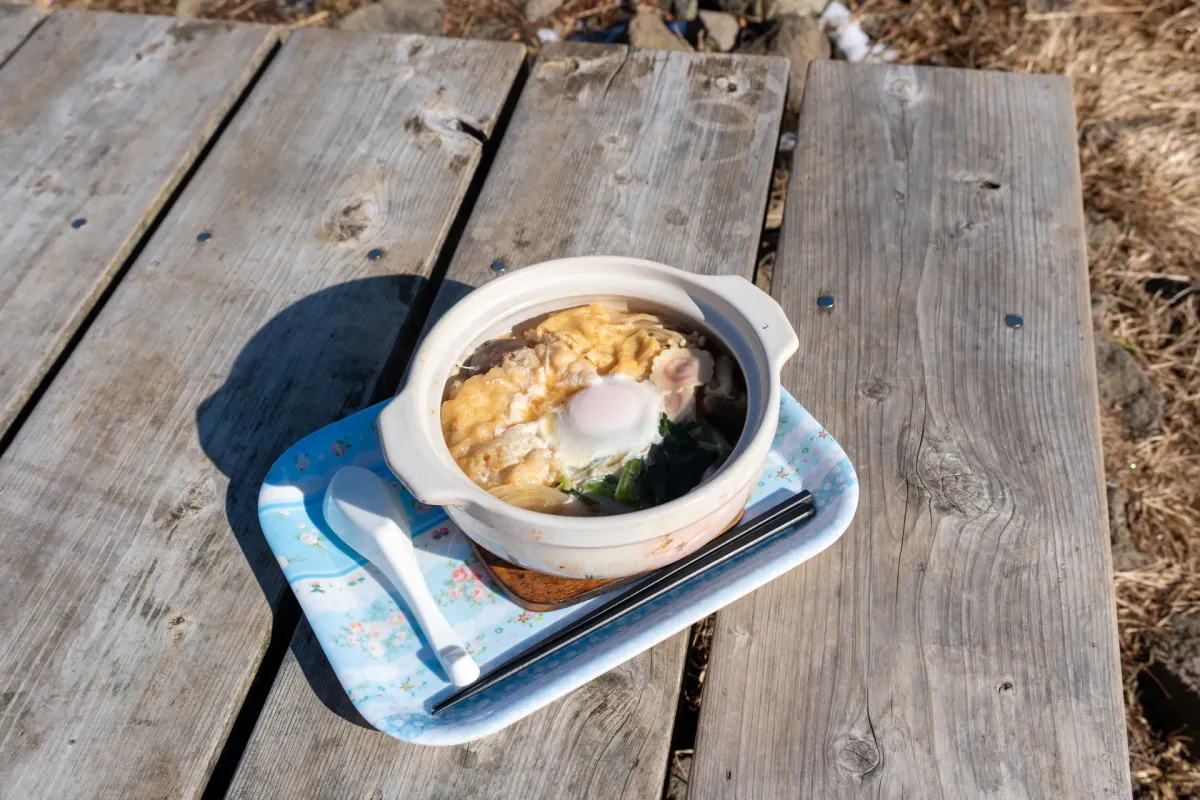
Before ordering, you will have to find a spot to drop your backpack, as they don’t want you to wait with your backpacks in line. The udon costs 2000 yen, and it’s recommended to bring exact change to make it easier for them.


For reference, when I last visited Mt Nabewari 2 years ago, it was a Saturday in November, and when we arrived at 10:30am we ended up waiting 30 minutes to get our bowl of udon, so there can be a bit of a wait depending on when you visit. Today was a weekday though, so I didn’t have to wait at all.

I got my bowl of udon, and it didn’t disappoint. You might be wondering what makes it so good. I think considering that someone has to haul all of these ingredients themselves up the mountain just to make this udon, you could hardly expect anything fancy, just some simple noodles.
So it’s surprising to get to taste the variety of ingredients - pumpkin tempura, spinach, mushrooms, an egg - plus the thick udon noodles that just makes for such a satisfying meal that you wouldn’t expect on top of a mountain. And of course, perfect to warm you up on a cold day in December too.

Reading up on the history of this hut, originally Nabewari Sansou sold a variety of hot dishes - like curry rice and ramen - but settled on nabeyaki udon as its sole menu offering as that was consistently its best-seller.
I’m not sure whether that’s because it was genuinely the most delicious, or maybe whether hikers saw the funniness in the naming - if you’re coming to a mountain named Nabewari, you have to get the nabe dish, after all. (The nabe “鍋” from Nabewari means “pot” in Japanese, and nabeyaki udon is a type of udon that is cooked in a pot).

Kusano-san, the owner of the hut, is now approaching his late 70s, and the article mentions that Mt Nabewari is now where he’s spent literally two thirds of his life, which is a pretty crazy amount of dedication to a mountain. When he first started running the hut nearly 50 years ago, he was warned off from the area due to its lack of popularity compared to other mountains in the Tanzawa region. Of course I’m sure he has no such problems now as the udon is quite an iconic dish of Tanzawa.


After Mt Nabewari, you can head back in the same direction you came down to the trailhead. I think that would be a little boring though (so much road) so I headed in the direction of Mt Tonodake instead to make a loop course.


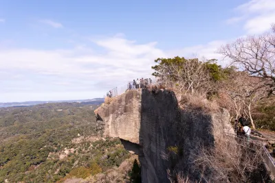
As you start hiking, you’ll be able to see the hut at the peak of Mt Tonodake up on the ridge on your left. It’s perched right on top of the peak so it really sticks out.


As I was pondering the existence of some deer fences (are they keeping the deer out, or in?) and enjoying how quiet this section of trail was, I stumbled upon a deer.

The deer was doing its best impression of a “deer in headlights” and was gracious enough to pause for me to walk around the fence to see if I could get a better view of it.

I managed to get this super cool shot in before it bolted. Felt like I was having a Princess Mononoke moment or something.

And if you look out on the right side of the trail, you’ll also be able to spot a blue-roofed building. From my hike up Mt Tonodake at the beginning of this year, I also spotted that same blue roof, but from the opposite side. So that distant ridge must be the Yabitsu-toge Pass.

Eventually you’ll come to a 3-way junction. To your left is the path up to Mt Tonodake, or you can skip it and head down the right path, which takes you back down to the Okura trailhead.
The detour up Mt Tonodake will take an extra 40 minutes, so I hesitated for a moment if I wanted to climb it or not (I have climbed it so many times at this point, after all) but the allure of climbing another peak got to me so up Mt Tonodake I went.


I got yet another great view of Mt Fuji from the peak of Mt Tonodake, and there were plenty of people milling about and getting their pictures taken.


I generally try and aim to be off Mt Tonodake by 1pm at the latest to make it down in time before it gets dark. It was still around 12pm so I knew I had plenty of time, so I enjoyed the sunshine for a bit before beginning my descent.


Along with the Mt Fuji views, you can also see out to the ocean in the distance. Today was such a pretty day for a hike, and a really good one to round off 2025.


This was my sixth time descending down the Okura ridge, so it’s all very familiar and comfortable terrain. Although it can be a bit of a gruelling 3 hours to climb it, I can’t help but have a bit of a soft spot for it (also it helps I was only having to descend it today).


You’ll also pass the burned remains of the 堀山の家 mountain hut, which burned down on the 11th of January 2026.


Including the hut at the summit of Mt Tonodake, you pass a total of 4 mountain huts on your way down, which is quite a lot for a trail of this length, and really speaks to Tanzawa’s popularity. I’m not sure if the hut painted green is in operation though - always seems to be shut.


As I finished the hike and headed down the road back towards the Okura bus stop, past all the small farms, I happened upon an orange sign outside of a local shop.


Well, if you are going to ask so nicely (and in English too), I can’t help but oblige - so I bought a bag of mandarins to take home with me. Only 200 yen, so a fair price.
I reached the Okura bus stop around 3pm, and was just in time for a bus too, so I got to hop on straight away. It was a bit of a sleepy journey home on the train. Once I got home I went straight into a relaxing hot bath, which is always a nice way to end the day in winter.
Hiking course options
| Date climbed | Length | Course time |
|---|---|---|
| 2025-12-23 | 17.4km | 9h15min (the expected time for an average hiker without breaks) |
You have two options to climb Mt Nabewari:
- A 16km, 7.5 hour out-and-back from Okura trailhead, taking the long road both there and back. This direct route is the shortest possible course and best if you really want to visit Mt Nabewari but aren’t too sure of your stamina. I’m not sure I would recommend it - long walks along a road can be a bit boring, especially on the descent.
- A 16km, 8.5-hour out-and-back loop course, with the option to also do a detour to Mt Tonodake, bringing the course up to 17.5km over 9h 15min. I would recommend doing this loop course over the out-and-back. You can skip Mt Tonodake though, as there are plenty of spots to get great Mt Fuji views along the trail without needing to visit the summit of Mt Tonodake specifically.
Public transport access with itinerary
Buses are available from the Odakyu line’s Shibusawa station in Kanagawa. There’s a bus timetable available here. If you get on the first train from Tokyo before 5am, you’ll be able to get to Shibusawa in time to catch the first bus that leaves at 6:48am.
| Time | Location | Transport | Cost | |
|---|---|---|---|---|
| 04:59 | Tokyo station (東京駅) | Train | 900 | |
| 06:39 | Shibusawa station (渋沢駅) | |||
| 06:48 | Shibusawa station north exit (渋沢駅北口) | Bus | 250 | |
| 07:03 | Okura bus stop (大倉) |
However note that since this bus route is so popular with hikers, you might not be able to get on the first bus, and you’ll have to line up for the next one. The next bus is at 07:02 so it’s not really a big deal if you miss one, though! If you’re really keen, make sure you get off the train from the carriage closest to the stairs (the second-last carriage) to beat the rush of other hikers. Take a right out the ticket gates, and then down the stairs on your right to the bus stop.
Okura station is the last bus stop, and generally everyone gets off here so you shouldn’t have any problems with missing the stop.
For the return trip, there are 3 - 4 buses per hour running back from Okura, so you can be fairly flexible with the return times.
| Time | Location | Transport | ||
|---|---|---|---|---|
| 16:38 | Okura bus stop (大倉) | Bus | ||
| 16:53 | Shibusawa station (渋沢駅) | |||
| 17:13 | Shibusawa station (渋沢駅) | Train | ||
| 18:44 | Tokyo station (東京駅) |
For the buses, you’ll get on from the rear exit, and get off at the front. They let you use IC cards like Suica, so remember to tap on when you get on the bus.
Otherwise, take a paper ticket from the machine and hand this together with cash to the driver when you get off (the ticket lets the driver know where you got on to calculate the fare).
When to hike Mt Nabewari
The Tanzawa mountain range is notorious for its leeches (ヤマビル or “yama-biru”) in summer, so I wouldn’t recommend coming here during the summer months. Since it only has a maximum elevation of 1272m, it will be quite hot anyway, so I recommend finding higher elevation mountains to climb during summer if you can.
The best time to climb Mt Nabewari and other mountains in the Tanzawa area is as it starts to get colder, like in October or November. You can enjoy the autumn leaves, and the chances of Mt Fuji being visible increase in the colder months.
By January the likelihood of snow increases, and there will definitely be snow in February/March, before it all starts to melt in April. So you will have another opportunity to climb in April - May, before the heat sets in!
I recommend checking YAMAP to see the conditions before you climb.
Read more


Support me
📸 Thanks for reading! If you'd like to read more posts like this one, you can follow me on Instagram to stay up to date on my hiking adventures.
If you found this post useful, you can show your support by buying me a coffee - I write this blog for fun, but coffee is always appreciated! ☕
Recent posts
 hikes
hikesMt Nokogiri: a hike to Chiba's stone quarry
18 Mar hikes
hikesMt Miura-fuji and the Miura Kaigan Cherry Blossom Festival
9 Mar hikes
hikesAkabokko: hiking in Ome
16 Feb
Leave a comment