I’ve compiled a list of some of my recommended day hikes from Tokyo, ranging from beginner to intermediate difficulties. As well as classic beginner-friendly hikes like Mt Takao and Mt Mitake which are only 1 - 2 hours from Tokyo, I’ve included mountains as far afield as Tochigi, Gunma and Fukushima, which are surprisingly accessible as a day trip if you don’t mind paying the Shinkansen fare. With elevations ranging from 329m to 2956m, there’s mountains for every season, and with most having ropeway access, you’ll get some stunning views for not too much effort at all.
I’ve broken down the hikes based on how far they are from Tokyo via public transport below:
Hikes under 2 hours from Tokyo


Hikes around 2 hours from Tokyo


Hikes within 3 hours of Tokyo


Hikes 4+ hours from Tokyo (but still daytrip-accessible!)


Mt Takao, Tokyo

Mt Takao
Mt Takao (高尾山) is by far the most popular mountain in Tokyo, with a variety of hiking trails accessible in all seasons, and being only one hour from Shinjuku by train. With cablecar access, you’ll be at the summit in less than an hour. If luck is on your side, you’ll even be able to see Mt Fuji from the summit!
Of course, with this popularity comes large crowds, and if you take one of the easier routes it’s more of a long walk up a paved path rather than a true hiking experience. If you’re looking to stretch your legs and escape the crowds, I would also recommend the 15km Minami-Takao Seven Summits course (南高尾セブンサミッツ) which takes you in a heart-shaped loop around some of Takao’s lesser known peaks, before you end your hike at the peak of Mt Takao itself.

Access to Mt Takao is via train on the Keio line to Takaosanguchi (高尾山口) station.
Mt Takao is climbable nearly all year around. Tokyo gets snow a couple days of the year at most, so if you’re concerned about snow, as a rule of thumb if it’s cold enough to snow in Tokyo there’s probably snow on Mt Takao as well.
Mt Jinba, Tokyo

Mt Jinba
Directly next to Mt Takao is Mt Jinba (陣馬山), which comes with a rather suspicious-looking horse statue at its peak. If you want to visit Mt Takao but are looking for a more difficult hike, this is a great option as the course is a 7-hour, 15km traverse that first has you climb to Mt Jinba, before hiking across to Mt Takao. Mt Jinba also comes with better views of Mt Fuji than Mt Takao, thanks to its slightly higher elevation.
For public transport access, you’ll need to get the train to Takao (高尾) station, and then a 30 minute bus to Jinba-kogen (陣馬高原).
Similar to Mt Takao, Mt Jinba is climbable nearly all year around. I have done the trail from Mt Jinba in February with no problems!
Akabokko, Tokyo

Akabokko
Akabokko is a 410m peak overlooking the town of Ome on the western edge of Tokyo. It’s also a convenient station-to-station hike from Miyanohira station to Ome station, just a 90 minute train ride from Tokyo. It’s a little on the quieter and more “local” side than some of the other hikes, but it has some cute quirks, like the painted Ghibli-esque stones at the summit.
At only 400m of elevation, it can get quite hot in the warmer months - so I would class this one as a good winter hike.
Mt Oyama, Kanagawa

Mt Oyama
Moving out of Tokyo, there’s plenty of mountains to check out in the neighbouring Kanagawa prefecture as well. One of the most popular is Mt Oyama (大山) in the Tanzawa mountain range. With cablecar access, you’ll be looking at a 3 - 4 hour hike to the summit and back. Without using the cablecar, you’ll about double your hike to take 6 hours.
A particular highlight and recommendation from me is the matcha tiramisu you can buy at the cafe at the top of the ropeway. If you’re lucky, you’ll get a sunny balcony seat with views out to the city in the distance.

Public transport access is via a 1 hour train from Shinjuku to Isehara station on the Odakyu line, and then a 30 minute bus ride to the cablecar station.
Mt Tsukuba, Ibaraki

Mt Tsukuba
Mt Tsukuba (筑波山) in Ibaraki has the distinction of being the lowest in elevation of Japan’s Hundred Famous Mountains. It’s also known for having two peaks, Mt Nyotai and Mt Nantai, from which you’ll be able to get sweeping views out to the farmlands and city of Tsukuba below. Using the ropeway, you’ll be able to visit both peaks in about an hour. Without it, a hike will probably take you in the range of 3 to 4 hours.
Public transport access is via the 45 minute Tsukuba express from Akihabara station to Tsukuba station, and then a 35 minute bus. Although Ibaraki sounds quite far, the price is fairly reasonable - the round trip cost for both the train and bus will cost you only 3850 yen.
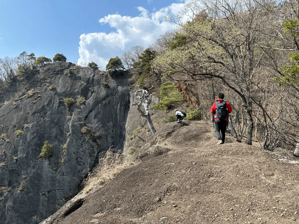
Mt Iwadono, Yamanashi

Mt Iwadono
Mt Iwadono (岩殿山) is quite a fun mountain, and a little bit different from the other ones I’ve mentioned so far. The trail has some short sections you will need to climb/descend via a chain rope, and takes you along a rounded cliff-face that you can get close to the edge of, if you’re brave!
The course is 4.5 hour, 8km loop starting and ending at Otsuki station. Along the way you’ll pass Maruyama park (丸山公園) which was so beautiful when I visited in April with its sakura trees. Compared to how crowded Tokyo can get, it was really nice to be able to enjoy the sakura without many people around. I recommend visiting in April!

Mt Iwadono is also a part of Otsuki city’s “12 views of Mt Fuji” so on a clear day you’ll might get the chance to see Mt Fuji in the distance as well.
Public transport access is via a 100 minute train ride on JR’s Chuo line to Otsuki station.
Mt Mitake and Mt Odake, Tokyo

Mt Mitake and Mt Odake
Mt Mitake (御岳山) in Okutama is also a popular hiking destination within 2 hours of Tokyo. Using the ropeway, expect only a 1km or 30 minute walk to the summit of Mt Mitake and its shrine. From here there are multiple options to extend your course, including a hike out to the neighbouring Mt Odake.
Public transport access is under 2 hours by train from Tokyo to Mitake station on the JR Chuo line, and then a 10 minute bus trip from the station to the Mitake cablecar.
Mt Mitake can be climbed nearly all year round, although it’s best to double-check the trail conditions in the winter months. It’s also particularly popular in November if you’re looking to catch the autumn leaves.
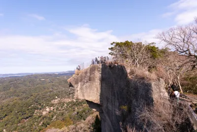
Mt Nokogiri, Chiba

Mt Nokogiri
Chiba is not really known for being a hiking destination, but one of its more popular peaks is Mt Nokogiri. It’s famous for being the site of a huge stone quarry, which you can still see the remains of, and a 31m tall Buddha statue carved into the wall.
By starting your hike at Hama-Kanaya station (浜金谷駅), you’ll be able to do a 3 hour, 5km loop course that passes by the rock quarry. As you approach the summit, there’s also the iconic Hell Lookout or “Jigoku Nozoki” which makes for a great photo opportunity.

There is also a ropeway about a 10 minute walk from the train station to make your hike easier as well.
Public transport access is to Hama-Kanaya station (浜金谷駅) which is a 2 hour train ride from Tokyo.
Mt Tonodake, Kanagawa

Mt Tonodake
If you’re looking for more of a challenge, Mt Tonodake (塔ノ岳) in Kanagawa’s Tanzawa mountain range is a great option. I would put the 13km trail at a hard difficulty as it will take you 8 hours to complete, but you’ll be well-rewarded with some views of Mt Fuji if you get lucky with the weather.
Mt Tonodake is only 2 hours from Tokyo, first via a train to Shibusawa station, and then a bus to the Yabitsu-toge trailhead.
Mt Tanigawa, Gunma

Mt Tanigawa
Mt Tanigawa (谷川岳) is renowned for its scenery in the autumn season, although unfortunately I got unlucky with some clouds so I wasn’t able to properly appreciate its grandeur. After getting off the Tanigawadake Ropeway, expect a 6km, 5 hour hike up to the summit and back. There are some slightly steeper sections, so although it’s not too long, I’d class it on the lower end of an intermediate difficulty.

For those looking to extend themselves, there’s the option to skip the ropeway on the way up to climb up a course with 1400m of elevation gain over some very steep rock faces.
Public transport access is via a shinkansen and local train to Doai station. Taking the first Shinkansen out of Tokyo, you should be able to take the ropeway up and begin your hike before 10am. The round trip including the ropeway fees will come to around 20,000 yen.
Mt Tanigawa’s climbing season is from mid-April to mid-November, which also lines up with the operating season for its ropeway.
Mt Mitsutoge, Yamanashi

Mt Mitsutoge
For those looking to get a more up close and personal view of Mt Fuji, Mt Mitsutoge (三ッ峠山) is one of the more accessible mountains in the Fuji Five Lakes area.
The shortest course is a 5km out-and-back course starting and ending at the Mitsutoge trailhead bus stop which you can do in under 3 hours. The views are great, especially if you get a chance to see Mt Fuji at the top. If you have more time, you can keep going from peak all the way to Kawaguchiko station, for a total 12km, 5.5 hour course.

For public transport access, you’ll first need to get to Kawaguchiko station. You can get here either by bus or train in about 2 - 3 hours from Tokyo. From there, it’s a 25 minute bus ride to the Mitsutoge trail head (三ッ峠登山口) bus stop.
Mt Kumotori, Tokyo

Mt Kumotori
If you’re looking for a challenge, you can climb Tokyo’s highest mountain, Mt Kumotori (雲取山). Its 20km course is commonly done as a 2-day hike with a stay at the summit, but for those with stamina, it’s also possible to do as a day hike.
Access is via 2 hour train ride to Okutama station, and then a local bus to the trailhead.
Mt Daibosatsu, Yamanashi

Mt Daibosatsu
Mt Daibosatsu (大菩提山) is another mountain where you can get a great view of Mt Fuji. It’s a little bit further out of Tokyo compared to Mt Mitsutoge, but you can get a really cool shot of Mt Fuji together with the Kamihikawa dam.
The standard loop course is only 3 - 4 hours, so this is another beginner-friendly option with some great views. Depending on the snow conditions, you should be able to hike Mt Daibosatsu from mid-April to the end of November.
Mt Chausu, Tochigi

Mt Chausu
Mt Chausu (茶臼岳) is one of my favourite mountains. There’s absolutely no trees, so you just get a long view of exposed, orange-looking ridge lines for your entire hike. With a ropeway taking you to near the summit, you can do the hike in as little as 1.5 hours and 2km, or extend your hike with options for 5km and 12km courses as well.
For access via public transport, you’ll first get a Shinkansen to Nasushiobara station, before taking a 70 minute bus to the trailhead. The round-trip comes in at 15,000 yen, which is a little on the pricier side, but still reasonable for a day trip, especially if you’re looking for something a bit different to the other mountains on this list.

If you’re coming by bus, this will dictate when you can hike this mountain, as it only runs from April through to the end of November.
Mt Adatara, Fukushima

Mt Adatara
Mt Adatara (安達太良山) is all the way out in Fukushima and so it’s definitely on the pricier side at a 20,000 yen round trip from Tokyo, but still surprisingly accessible as a day hike. I once chatted with an old hiker who told me he had climbed all of Fukushima’s “100 famous mountains” and that Mt Adatara had the prettiest autumn scenery, so October may be the best timing to hike this mountain. If you were looking to make a weekend trip out of it, I’d also recommend the nearby Mt Bandai.

Mt Adatara’s climbing season without snow is from mid-April through to early November.
Mt Zao, Yamagata

Mt Zao
Mt Zao (蔵王山) is famous for its green Okama crater lake, and is also well-known as an onsen town and ski resort in winter. Although it’s all the way in Yamagata prefecture, it is accessible as a day trip from Tokyo if you don’t mind paying an eye-watering 28,000 yen (roundtrip).
The views are stunning though! And since you take the Shinkansen it’s a long but comfortable 4 hour trip from Tokyo to the ropeway station. From the top of the ropeway station, it’s a 4 hour, 9km out-and-back course first to the summit of Mt Zao, and then onto the Okama crater itself.

Mt Zao’s hiking season is from late May to mid-October.
Mt Nikko-Shirane, Tochigi

Mt Nikko-Shirane
If you’re looking for something slightly higher in elevation, Mt Nikko-Shirane (日光白根山) is a great intermediate-difficulty hike in Nikko National Park. It’s also the tallest peak in both Tochigi and Gunma prefectures.
As it’s a higher elevation mountain, the hiking season is a bit shorter, and you’ll be able to hike snow-free between mid-June and October.
Depending on which course you take, expect to hike 7 - 9 hours, which may be a little bit a tight squeeze as a day hike, but doable if you have the stamina. The bus to the trailhead departs from Nikko station, and you’ll be looking at a bit over 4 hours travel one-way. It’s quite far, but well worth the effort!
Mt Kiso-komagatake, Nagano

Mt Kiso-komagatake
Mt Kiso-komagatake (木曽駒ヶ岳) just squeaks onto this list. But I couldn’t help but add it - this is the closest you’re going to get to 3000m on a day hike from Tokyo. The timings are a bit more feasible if you drive, but with public transport you should be able to squeeze in the shortest 3.5 hour course. The views are stunning and well worth the effort.

Since it is quite a high elevation mountain, the hiking season is from the end of June to the end of October. Outside of these months, expect there to be snow.
Looking for more hikes?
Japan has so many great mountains to hike that it was honestly so hard to narrow it down to only 18. You can check out all of my hiking reports on my main hiking in Japan page. I also have a page dedicated to winter hiking in Tokyo as well as one for hikes around Mt Fuji.
Happy hiking!
Read more


Support me
📸 Thanks for reading! If you'd like to read more posts like this one, you can follow me on Instagram to stay up to date on my hiking adventures.
If you found this post useful, you can show your support by buying me a coffee - I write this blog for fun, but coffee is always appreciated! ☕
Recent posts
 hikes
hikesMt Nokogiri: a hike to Chiba's stone quarry
18 Mar hikes
hikesMt Miura-fuji and the Miura Kaigan Cherry Blossom Festival
9 Mar hikes
hikesAkabokko: hiking in Ome
16 Feb
Comments
Leave a comment