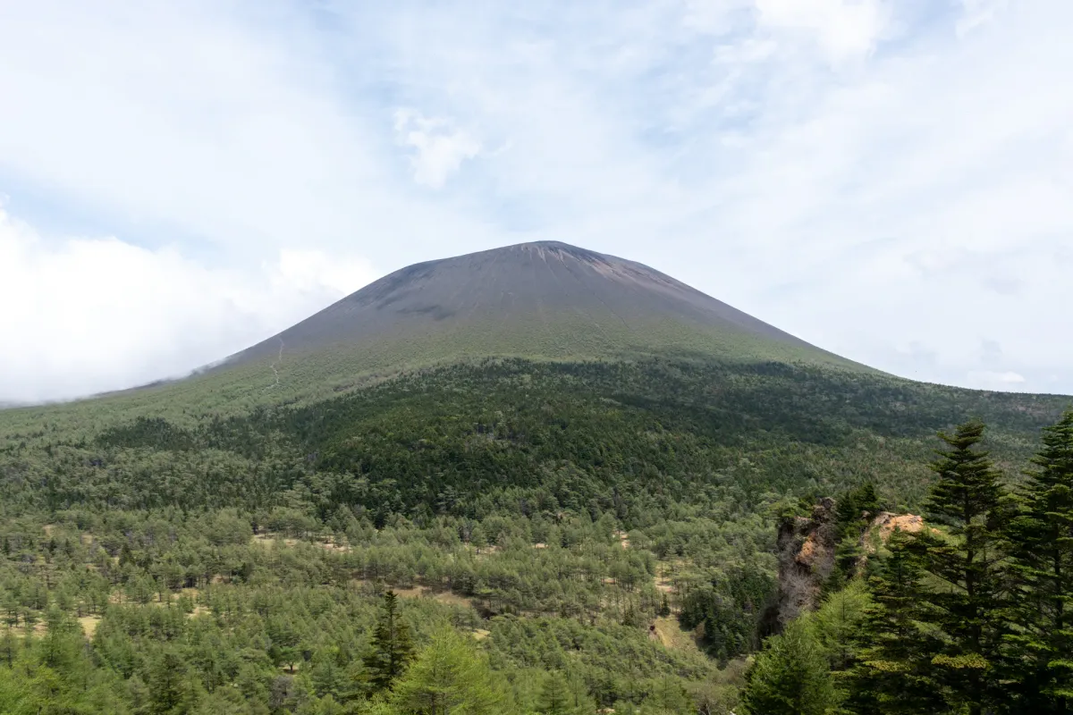
Mt Asama (浅間山, asama-yama) is one of the Hundred Famous Mountains of Japan located in Nagano prefecture, near the resort town of Karuizawa. As Mt Asama is still an active volcano, access to the peak itself (right on the volcano’s crater) has been closed off for more than 50 years. The peak of Mt Maekake (前掛山, maekake-yama) is on a ridgeline just 500m away from the crater and is the official stand-in for those looking to conquer the Hundred.
However even Mt Maekake had been closed off for the last 3 years as the volcano had remained at a “Level 2” for volcanic activity. When the peak returned to a Level 1 just over a week ago, I jumped at the opportunity to give this mountain a climb.
Hiking Mt Asama: a quick summary
Accessible in just under 3 hours from Tokyo via a Shinkansen to Sakudaira and then a local bus to the trailhead. As a day hike the timings might be too tight, in which you can stay at the trailhead's hotel.
- Takamine Kogen loop (ridgeline walk via Mt Kurofu)hardTrain + bus8.5 hrs·13.9 km·↑ 1380m
- Asama sansou out-and-backhardTrain + bus7.5 hrs·12.7 km·↑ 1174m

I started my hike from the Takamine Kogen Visitor Centre, with a rather foggy start at 6:30am. It was a Wednesday, so you might expect the carpark and hiking course to be less crowded, but I have heard Mt Asama has been quite a busy mountain this week, with everyone rushing to take the chance to finally summit this mountain which has been closed off for 3 years.

At the trailhead you can fill out and submit your tozan-todoke (your climbing plan which gets given to the authorities in case anything goes wrong) and verify that today is indeed a “Level 1” for hiking up to Mt Maekake.

I was quite dubious of getting to see anything with how foggy it was, but as I started to climb and the sunlight filtered through the trees, luckily I realised that it was really only the carpark that was foggy.


For a mountain that’s been closed off for 3 years, you might be surprised at how well-maintained the trail still seems to be, and this is because even if the mountain is a Level 2, you can still approach it partway, and many people do variations on this hike without actually summitting the peak itself.

As you climb, the first piece of evidence that this is an active volcano comes into view - there is a small emergency shelter here.


About an hour in, I reached the first peak of the day, Yarigasaya (槍ヶ鞘, 2281m) and I was relieved to see just how clearly I could already see the peak of Mt Asama in front of me. Yay!

Continuing with a bit of a rocky climb up, you’ll head up to the next peak of Tomi-no-kashira (トーミの頭).


トーミ (Tomi) takes its name from 遠見 (“distant view”) - i.e. you can see the peak from really far away.
From the peak of Tomi you can see out to Mt Fuji and other distant mountain ranges.

Just beyond Tomi, the trail will split in two - you can either take the ridgeline walk towards Mt Kurofu (黒斑山) on the left, or down the Kusa-suberi (草すべり, or “grass slide”) down the right. I was planning on doing this as a clockwise loop, so I took the ridgeline walk out, and then climbed up the Kusa-suberi on the return. It does seem like doing the course counter-clockwise was the much more common option, though.

Whilst climbing from the carpark, I had noticed a series of black tubes that followed the trail up most of the way - I was curious what they were for, because to my knowledge there weren’t any mountain huts up here.

The mystery was solved when I spotted a large set of speakers. I assume this would be used in case of an emergency to alert hikers to an impending (or ongoing) volcanic eruption.

The first peak you’ll reach on the ridgeline walk is Mt Kurofu (黒斑山, 2404m). Even if the volcano is at a Level 2, you are still able to climb up to this point. This is actually a common winter hike done with snowshoes.

Japanese hikers have nicknamed this view of Mt Asama in winter the ガトーショコラ (gateau chocolat, i.e. French for “chocolate cake”). I suppose because it looks like a chocolate cake with white icing sugar on top.

Continuing on with the ridgeline walk you get to enjoy continuous views of Mt Asama there in the distance.

The next peak is Mt Jakotsu-dake (蛇骨岳, 2366m) which translates to “snake bones”. The rocky summit is supposed to resemble the skeleton of a snake.

I felt myself hurrying along this ridgeline a bit, because I could see a cloud of smoke or fog seemingly creeping up the side of Mt Asama.

The next peak along is Mt Sennin-dake (仙人岳, 2320m).

You’ll notice all the peaks so far have been in that 2300m range, and so really this part of the hike is quite comfortable, there’s not too much elevation gain or loss.


As you keep on the ridgeline, you’ll pass a 2km zone sign - if the volcano is at a level 2, you are not allowed past this point. And of course, even at a level 1, the hike is to be done at your own risk.

You’ll then reach the “J-band” intersection, which is where you take the descent path into the forested plateau below. But before that, you can press on another 5 minutes for one more optional peak you can bag.


This is Mt Nokogiri-dake (鋸岳, 2253m) which is the 4th peak along the ridgeline.

Nokogiri means “sawtooth” which explains the peak marker with a jagged bottom.
Next, you’ll descend down the J-band. The first part is rather steep and rocky, so out of an abundance of caution I decided to stow my trekking poles away.

Maybe I didn’t need to though - although at least best to shorten them down so they are not in your way as much. It’s quickly over and then it’s a steep set of switchbacks on a rocky path down to the plateau below (which it is helpful to have your trekking poles out for).


Then there’s a short section of forest.


When you reach the starting point of the final climb up Mt Asama, there’s a rather large sign warning you of the dangers.

It was around 9am at this point, and there were already plenty of people coming down the mountain already - they must have had a super-early start.

As I began my climb, I took a look back at the view of the ridgeline and really, I was in awe. On the left you can see out to the Tomi-no-kashira.

And then out to the peak of Mt Nokogiri-dake on the right.

I thought I couldn’t get the whole thing in my camera’s frame - and then I realised it had a panorama mode.

The climb up feels rather long - it is a continuous climb with 400m of elevation gain.

As you climb and look back towards the ridgeline, you can make out some snow-tipped peaks in the distance behind it (I think it was the Northern Alps).

Once done with the climb, you’ll see the peak of Mt Asama ahead of you - blocked off with rope. It may be obvious to say, but do not attempt to climb up to the peak, even if the volcano is at a level 1.

There are also two emergency shelters available up here. I would say that maybe 50% of the hikers I saw today had brought along helmets - some wearing them, while others had them strapped to their backpacks for easy access. The main risk with a volcano eruption is that it can shoot rocks into the air which would be probably lethal if it hit you. Of course, with Mt Asama only at a level 1, you could say that it’s safe enough to not need a helmet so it’s more of a personal safety decision (they are not mandatory).

It’s a bit of a tough climb up to here, so plenty of people had plopped down on the rocks around the shelters to take an early lunch break, and I did as well.

Then there’s one final ridgeline walk up to Mt Maekake.


There were so many swallows Pacific swifts swooping overhead at high speeds, and so I spent a bit of time waving my camera around like a lunatic trying to get a non-blurry photo with them in the frame.

And then it’s to the peak of Mt Maekake! From here you can see out towards the Mt Asama crater.


Up on the ridgeline, it felt so cool to be above the clouds.


Heading back down, the emergency shelters came back into view.

And then it was back down the way I came, with a great view of the ridgeline. The first part of the descent is pretty steep and slippery with the loose gravel, so some trekking poles do come in handy here.

Back at the foot of the mountain, I headed into the forest.

At the beginning of the forest, I saw a sign which noted that the forest junction point is called the Sai-no-kawara (賽の河原) which had been translated in English as “Children’s limbo”. The original image that floated into my mind was some children dancing under a pole and playing a game of limbo. The actual meaning is a bit more grim, as it refers to the limbo between life-and-death. (In Buddhist teachings, children cannot pass into the afterlife).

A rather novel scene for Japanese hiking trails - I also passed through a rather grassy field.


Eventually you’ll come to a junction point from where you can descend down towards the Asama sansou (a separate trailhead). Notably there is an emergency hut just 300m down the trail, so if you happened to be running away from a volcanic eruption, you should head in this direction.

In my case the volcano was behaving nicely, so I took the right turn and headed up the Kusa-suberi.

This is the cruelest part of the course - you’ve done your climb up to Tomi-no-kashira, walked the ridgeline, dropped down into the plateau, and then done the 400m elevation gain up to Mt Asama and back down again. However, you’ve now got to climb back up onto that ridgeline and get on the other side of it to get to the carpark, so from here there is a very steep 300m elevation climb up to Tomi-no-kashira.

This rather punishing climb is possibly why people tend to do the course in the opposite direction - they can drop down into the plateau via this route, and then finish by taking the slightly less harsh climb up via the J-band and then along the ridgeline.

Although steep, when you inevitably stop to take a rest, you can get some really nice views of Mt Asama. This was my favourite view for today - in the morning it was a bit glary with the morning sun, so this was perfect in comparison.

Even from this distance, you can make out the people walking along the ridge up to Mt Maekake which is pretty cool.
After my descent of Mt Maekake and while walking through the forest, I passed a hiker heading towards Mt Asama who seemed quite urgently to want to know if I had spotted any mountain flowers on my climb up. Unfortunately, I had to tell him no (and he told me that everyone he had asked had said no so far).
I don’t always take photos of the flowers, but decided I better take photos of these two I spotted in his honour.


This final climb back up to Tomi was quite steep, which on one hand is tough, but also I feel would be quite hard also to have to descend via so I felt pretty happy with the clockwise approach that I took. I was also surprised by how many people I passed who were heading down at this time. It was already past 12, so a bit late in the day for a climb up Mt Asama. But I suppose plenty of people just do the ridgeline hike, or possibly head down into the forest and then descend via the Asama sansou trailhead.

Once I made it back up to Tomi, I took in another view of Mt Asama - some clouds had started to roll in - and then started on my descent.


On the climb up, there had been two hiking course options - the “naka” course or the “ura” course. I took the “ura” up and I debated whether I should take the “naka” down, but looking at YAMAP the “naka” course would add another 10 minutes onto my descent and it seemed like one part was rather slippery, so I chose to take the “ura” back down as well.


The hike down took under an hour, and it didn’t really feel too long. It had been such a nice hike today that I was in pretty high spirits.


There is one tiny climb at the end which you have to get through.

And then it was back to the carpark! I was surprised by how many cars were still here, but I suppose with the number of hikers I had passed heading in the opposite direction, any spots that had become available from early morning hikers who had already finished was probably taken by these midday and afternoon hikers.

This was my first hyakumeizan of 2026, and my 67th overall - and it was a really good one to kick off the summer hiking season. My favourite features when hiking mountains in Japan tend to be:
- Volcanic mountains (i.e. no trees, lots of scenery)
- Ridgeline walks (even more scenery)
- Hikes where you can see the entirety of the peak on your approach: there’s just something cool about seeing a peak and being like “I’m going to get to climb that!”
Mt Asama hit that trifecta for me perfectly, and the weather was so nice too. So I was just really pleased overall with this hike. We’ll have to see how long the volcano stays at a Level 1, but if you have the chance, this was an awesome hike and I would totally recommend it.
Hiking course options
This is a clockwise loop course that starts and ends at the Takamine Kogen Visitor Centre. After climbing out to Tomi-no-kashira, you’ll head out on the ridgeline from Mt Kurofu to Mt Nokogiri-dake, descending via the J-band, climbing up Mt Maekake, and returning via the Kusa-suberi. Weirdly YAMAP doesn’t seem to have an official course listed for this, so you will have to copy another user’s route. You can also take the loop counter-clockwise, in which case there’s an example of someone else doing it here.
This is an out-and-back course from the Asama sansou trailhead. Unlike the loop course, it’s fairly straightforward in that it’s one steady climb, and then one steady descent. It’s a little bit shorter as well, but the one downside is that you miss out on some of the great views you can get from the ridgeline walk.
Public transport access
There are two buses a day departing from Sakudaira station - at 8:40am and 2pm (you can see a bus timetable here).
Looking at the timings, this means you could get an early morning Shinkansen out of Tokyo, and then on the 8:40 bus, which arrives at the Takamine Kogen Hotel at 9:34am. This is right next to the Visitor Centre and is the starting point of your hike. However the final bus back from Takamine Kogen departs at 4:20pm. This gives you under 7 hours to complete the hike. As the loop hike is expected to take up to 8.5 hours for a regular hiker (for reference, I was able to do it just in 7 hours) you would have to be sure that you are fast enough to complete it in time.
Alternately, you can spend a night at the hotel. In which case you can get on the 2pm bus from Sakudaira, and get to the hotel at 2:54pm. With an early start the next morning, you should be able to finish your hike in time for the return bus at 4:20pm.
As well as getting a shinkansen to Sakudaira station (which will cost about 6500 yen one way), a cheaper option is to get the highway bus from Shinjuku station to Sakudaira station (3000 yen one way) - timetable here. With the timings though, this would only be viable if you are planning on spending the night. It does seem like a bus was originally running from Shinjuku all the way to Takamine Kogen, but that no longer seems to be available as of June 2026. Maybe they will bring it back at some point, now that the trailhead has reopened.
The bus back runs twice a day at 10:13am and 4:20pm. As mentioned above, you will probably want to get on the 4:20pm return bus.
Similar to the Takamine Kogen bus route, you would get on the same bus, but get off partway at the Asama trailhead bus stop. The downside of this is that from here, you have to walk 4km (70mins) up a road to get to the actual trailhead at the Tengu Onsen.
The Tengu Onsen is also the site of a lodge called Asama Sansou so like the hotel option, if you are doing an overnight hike you can spend a night here. Personally having to hike up the road doesn’t sound like an appealing option, but it could do in a pinch if you couldn’t get a booking at the hotel.
The Asama Sansou also has a separate campsite (1100 yen per person) which is a more affordable option.
Since the bus route first passes the hotel and then the Asama trailhead, you would get on the bus partway here. You can get on the bus at 10:30am or 4:38pm. Keep in mind though that after you finish the hike, you are going to have to leg it 4km down the road to get to the bus stop (oof).
Car access details
As mentioned above, there are two separate trailheads, and hence two separate places where you can park your car:
- The Asama sansou / Tengu Onsen’s parking lot: this one is a paid carpark, run by the Asama Sansou. It costs 500 yen to park here. Note that you cannot park here overnight.
- The Takamine Kogen Visitor Centre: this one is free, although it’s not a huge carpark. The upside of this location is that there is a secondary carpark a further 10 minute walk down the road at the Takamine Mountain Park, which is a ski resort in winter.
I tend to worry a bit about whether I can get a car spot when I go hiking, so that’s the main reason why I opted for the Visitor Centre car park (well that, plus the hiking course itself seemed better). If you want a shorter hike, then you would want to opt for the Asama sansou’s carpark.
Sleeping in your car
Since it’s a 3-hour drive from Tokyo to the trailhead, plus a 7 - 8 hour hike, for me that’s a bit beyond the range of a day trip. I envy the endurance of people who can pull it off, but personally I find it a bit too tiring to drive both ways and hike on the same day. I suppose it might be easier if you had at least two people so you could share the driving duties.
In my case, I chose to drive out from Tokyo in the afternoon, sleep in my car, and then start my hike the next morning. Personally I don’t like to sleep at trailheads so much, so I had two options for michi-no-eki (roadside stations) in the nearest town:
- Michi-no-eki Raiden Kurumi no Sato (道の駅 雷電くるみの里)
- Michi-no-eki Mimaki (道の駅 みまき)
They’re both about a 30-40 minute drive from the Visitor Centre trailhead. Raiden Kurumi no Sato seems to be the more interesting option, as it’s themed after the birthplace of Raiden, an Edo-era sumo wrestler. I opted for Mimaki though as it had an onsen onsite.

The onsen is called Mimaki-no-yu, and is only 650 yen for entry (soap and shampoo available, plus an additional 100 yen for the hair dryer). It was open until 9pm, which is pretty convenient for me coming from Tokyo.
It had an outside rotenburo which was so nice. I can imagine if you came in the colder months at night when the sun had already fully set, the night stars might be really pretty from here.
The onsen was pretty lively with a bunch of locals chit-chatting about water consumption and rice farming (apparently in Okinawa the climate allows farmers to harvest twice a year). It seems they use this space as a gathering space each night, so it seemed a lot more lively than other onsens I’ve been to.

I slept pretty well! There was one truck that pulled in overnight which woke me up, but other than that it was a good sleep.


Alternatively if you prefer sleeping directly at the trailhead (which might be advised on the busier weekends anyway), the Visitor Centre has a toilet that’s open 24/7 so this is a viable option. The drive up to the VC is along a long, 10km winding road, but it’s all paved so very smooth.
When to hike Mt Asama
Mt Asama (i.e. Mt Maekake) is only hikable when the eruption alert level is dropped to Level 1. Since March 23, 2023 it was at a Level 2, but has just recently returned to Level 1 from May 23, 2026. If the volcano is at a Level 2, you can climb as far as Mt Kurofu (黒斑山) from where you can get a nice view of Mt Asama in the distance, but you cannot do the entire loop course.
The Gunma prefecture website has the latest details on the current warning level of the volcano. Another quick way to check would be to see the latest trail activities on YAMAP for Mt Maekake. Other than the occasional person who will probably climb it regardless of the warning level, if you see basically no one hiking up to the peak, that for sure means the mountain must be closed.
In terms of the hiking season, it seems like the snow-free season for hiking Mt Asama generally runs between mid-May through to the end of November each year. An example of early May conditions, you can see here that there is a small section of trail where you will cross snow.
PS: Animals you may see on Mt Asama
As a final fun note, I was jealous to see that a couple of days before my hike, a Japanese serow or “kamoshika” was spotted by hikers at a rather close range (see photos here and here). They are usually quite shy of humans, but it seems this one let multiple people get some close up shots.
In some other amusing news, a labrador was also spotted strolling the peak at Mt Maekake. It was confirmed to belong to the owners of the Asama sansou (6km) away so it seems to have escaped, climbed the mountain on its own and got to beg some water and snacks off of the hikers at the peak. You’ll be happy to know it was safely escorted back down the mountain and back to its owners. Apparently its name is “Nuts”.


Read more
See other hikes nearby

Comments
Thanks for the update on Mt. Asama - how "natsukashii" to see that J-Band again. Your preference for volcanic hikes would find great favour with Shiga Shigetaka, who said in his "Theory of Japanese Landscapes" (1894) that volcanoes were the essence of Japanese scenery.
PS: looking at the photo of the "swallows" (captured with a nice sun halo too), I wondered if they are really swallows or the somewhat larger and blacker alpine swifts that you find in a few mountain areas (ie top of Hoeizan crater on Fuji, and in Dakesawa on Mae-Hodaka). It would be interesting if they are nesting on Asama too - perhaps the crags around the outer crater might suit them....
Wow 1894 - same time as Hearn's first book.
And lovely, thank you! I hadn't even thought about the fact that it might be a different bird species altogether. This article seems to suggest it might be a Pacific swift. While I was there I remembered I had seen what I thought were swallows also at the peak of Mt Meakan - and that's probably another species altogether as well. Two new birds I can add to my list today!
Thanks for introducing the article with the video - which confirms that the birds are swifts (colour, size, flight pattern etc). It's hard to believe that they're actually nesting within the crater - but, then again, fumes and heat aside, this is exactly the kind of terrain they like to nest in. There is a colony on the very similar headwall of the (1707) Hoei-zan crater on Mt Fuji. Perhaps they like having centrally heated nesting sites .... : )
Ooh that's good to know, I had plans to eventually climb Hoei at some point so it would be nice to see them there too!
Leave a comment