Mt Takatsuma (高妻山, takatsuma-yama) is one of Japan’s Hundred Famous Mountains located in Nagano’s Myoko-Togakushi Renzan National Park. This National Park is home to four hyakumeizans (Mt Amakazari, Mt Hiuchi and Mt Myoko) and this was my last of the four to complete the set.
Hiking Mt Takatsuma: a quick summary
About 3 hours from Tokyo to the trailhead, with a combination of shinkasen and bus. Or a 3.5 hour drive from Tokyo to the trailhead.
- Togakushi campsite loophardBus9 hrs·12.6 km·↑ 1506m
Considering it’s at least a 3.5 hour drive from Tokyo to the trailhead, it may have been more efficient to climb Mt Takatsuma together with another mountain on one of my previous trips to the area - but I couldn’t get a clear enough weather window to fit two hikes in, so I came back this year to hike this one by itself. Since it is has an elevation of only 2353m, it does open up a little earlier than some of the 3000m+ Alps mountains, so it was the perfect choice for a June hike.

Since it is a long drive, I chose to sleep in my car the night before at a nearby michi-no-eki (roadside station), then drive up to the trailhead to begin my hike at 5am. It’s a fairly common starting time so even though it was a weekday, I was in good company with a couple of other hikers starting before and after me.
The start of the course takes you through the Togakushi Campground, which would be a good option to spend the night before, especially if you are coming via public transport.

The campground also comes with a memorial for “Mrs Weston” aka Frances Emily Weston - the wife of Walter Weston, the man who brought hiking to Japan. She’s not quite popular to warrant her own Wikipedia page (actually, Googling her brings up a fellow hyakumeizan blogger’s post on the topic). But it seems as well as climbing peaks like Mt Fuji and Mt Yari, she and her husband also climbed Mt Togakushi and Mt Takatsuma in 1904. The memorial was placed here to commemorate her being the first foreign woman to climb Mt Togakushi and Mt Takatsuma, and for helping to pave the way for future climbers.

Speaking of Mt Togakushi - I could see its peak rising up behind the campground.

Togakushi (戸隠) translates to “hiding door” and takes its name from a Shinto legend about the sun goddess Amaterasu. She hid in a cave, causing the world to go into darkness. Eventually the other gods managed to get her to come out, and the door of that cave landed here at Mt Togakushi. Interestingly the Togakushi Shrine’s English page says the door was merely “pushed” while the original Japanese puts it as having been thrown.
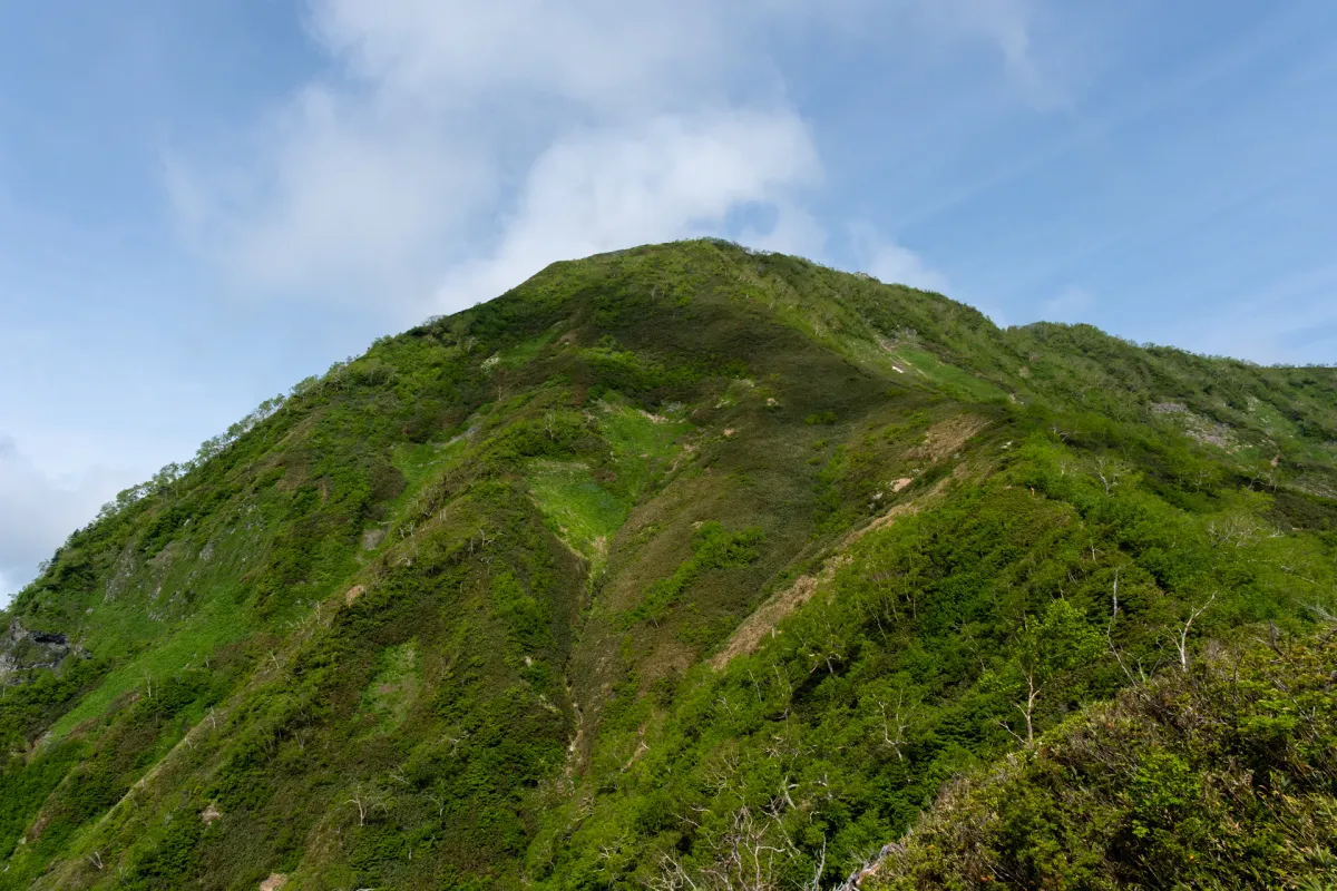
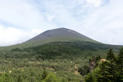
With such a history, you might wonder why the author of the hyakumeizan Kyuya Fukuda chose to bestow the title of hyakumeizan on Mt Takatsuma instead. Well for one, technically speaking Mt Takatsuma and Mt Togakushi are both part of the broader Togakushi mountain range - and Mt Takatsuma is specifically the highest peak in that range. And I suppose Mr Fukuda was quite partial to the peak of Mt Takatsuma itself - it has a more conical shape, and only chooses to reveal itself once you get much closer.

For those interested, you can climb Mt Togakushi and Mt Takatsuma together as a loop hike, but the climb up Mt Togakushi is a little more dangerous and more for the thrill-seeking type, so I chose to give it a skip.


To get to the trailhead, you’ll through a local farm / petting zoo. Technically there’s a small fee to enter, but as a hiker you are allowed to freely pass through on the way to the mountain itself. (I suppose don’t go petting any of the animals).

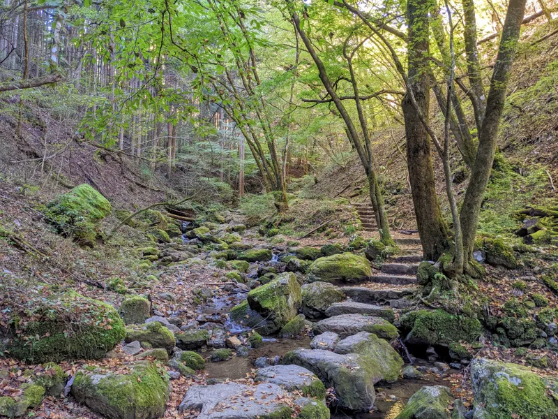
Once you’ve cut through the farm, the hiking course itself begins with a couple of stream crossings.


Probably the first one had the deepest water, but with some good balance you should be able to get through all of it without actually getting your feet wet.


There’s also a section of steeper climb along the stream you can do with the aid of a chain. It’s nothing too difficult, but if you have gloves it may be best to get them out, and stow away your hiking poles so you can climb up with both of your hands free.


It was almost tempting to get out my poles again, but you will eventually come to a second chain climb, plus walk along a narrow edge.

I was definitely holding onto the chain as I walked across - one slip would lead to a pretty steep fall - but the lady in front of me made quick work of it with only her hiking pole.

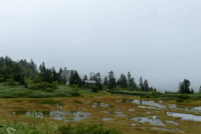
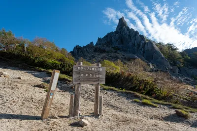
A little before 7am I made it to the Ichifudo refuge hut (一不動避難小屋), which has a couple of benches outside and is your first chance for a break. Some hikers will plan out their hikes with the intent of staying at an unmanned refuge hut, but this one explicitly had a sign on the door saying to not do this, and only use it in case of an actual emergency.


For sure, the inside of the hut was very barebones.
After a short break, I headed onwards! Beyond this point there are no longer any stream crossings, it’s just a series of ups-and-downs until you get to the peak of Mt Takatsuma.

At the end of June the mountain is teeming with mountain flowers - this guy on YAMAP managed to find quite the variety. Even if you had a foggy hike you could have a pretty fun time of spotting like 10 - 20 varieties.


As you keep climbing, you’ll start to pass numbered signs with little shrines.

I wasn’t sure if I missed the sign for the first one, but as I write this I’m realising the the refuge hut 一不動 would have been the very first one.
In ancient times, climbing mountains like these were done as a form of religious training for practitioners of a Buddhist religion known as Shugendo. (Notably Mt Omine and Mt Ishizuchi are famous peaks for this). These waypoints, of which there are 13 in total, represent the 13 Buddhas.

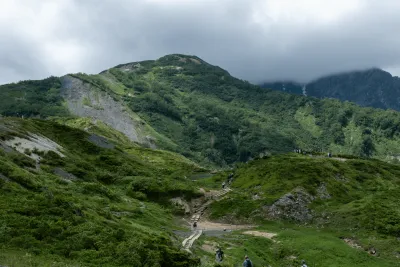
The morning had been pretty foggy, and so there wasn’t much for me to see as I came up to my first ridgeline.

Because of all the fog, I wasn’t too sure of my chances of seeing Mt Takatsuma today (not to mention we are in the rainy season anyway when chances of clouds are higher). So I was quite excited to finally get a glimpse of its peak in the distance.


Alarmingly, I also spotted a couple of huge tufts of white fur on the ground.

My dog used to shed like this (I could just pull the tufts out of him) so it was an almost familiar sight. I wasn’t too sure what it could be - at worst, a bear (although I wasn’t too sure they shedded white fur like this) or maybe somehow some fur from a goat on the farm managed to float up on the wind and make its way up here. Or maybe a bird brought it up for its nest?

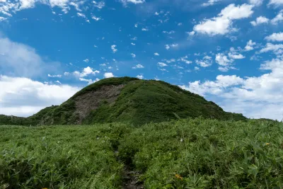
As well as Mt Takatsuma, there’s one more peak you can bag along the way - Mt Gojizo (五地蔵山). “Go” means 5, so this was representing the 5th out of the 13 Buddhas.
This one’s in a rather sheltered clearing, but if you continue for a further 5 minutes along the trail, there’s a much better viewpoint (and a good spot for a break).


Continuing on, I passed the markers for the sixth buddha, Roku-Miroku.

Along with the white chunks of fur I had seen earlier, what was even more confusing was the amount of poop that was on the trail (I will save you having to look at a photo). Not little pellets like a deer, but kinda human-sized (although it was green). I wasn’t sure if a bear was really having at it.
Pressing on, I heard some rustling, and then the flash of a monkey’s red bottom as it scurried away at the sight of me. Mystery solved! Although I was really quite amazed at the size of a monkey’s poo, in that case.


As I passed the seventh Buddha and got a better view of the left side of Mt Takatsuma, I could also see some snow-covered peaks behind it.


Mt Shirouma and Mt Tate are pretty popular peaks in the Northern Alps, but also both are ones I’ve yet to climb - I will have to visit one or both of those this year (of course, once the snow has cleared).

As I got closer to my unobstructed view of Mt Takatsuma, I could see the clouds fortuitously beginning to float away.

Taking a closer look, you can see the hiking trail curve up the right side of its face.

And out on the right, there’s a glimpse of a peak behind the clouds, striped with snow - which I think might have been Mt Hiuchi.

Your first fully unobstructed view of Mt Takatsuma also comes with the marker for the ninth Buddha, Kyu-Seishi.


The final climb up Mt Takatsuma gets rather steep and rocky, so it may be worth putting your hiking poles away at some point.


Once you’re climb up to the top, there’s a short (and rocky) ridgeline walk.


You’ll pass the 10th Buddha, Ju-Amida, and then the wooden peak marker for the summit comes into view.


The peak marker is a bit worn down and has seen better days. I arrived at the summit around 9:30am, and unfortunately I had managed to arrive right in the middle of some clouds. Looking at photos from later on the day on YAMAP, depending on the time of day you could get some nice views from up here.
From here, I retraced my steps all the way back to the 6th Buddha. So this involves a steep descent, and then some ups-and-downs.
There are 13th Buddhas in total, but you’ll only hit 10 on your climb up Mt Takatsuma. You’ll have to continue onwards to the adjacent peak of Mt Otozuma (乙妻山) to hit all 13.

If you remember the story of the monkey poo - there was still plenty of it on the return, but quite a few piles of it had since been trodden on by hikers (unfortunate for them).


Once I got back to the sixth Buddha, I took a fork in the path and began my descent.

This descent doesn’t take you over any streams, so it is also possible to do an out-and-back via this path if you wanted to skip the stream-crossings.

Some bits are rather steep, though. Luckily aided with some chain.


And I finally got to see the face of a nikko-kisuge flower pointing in my direction.

I know that these flowers reach peak bloom in mid-July on another nearby mountain, Mt Makihata so I would guess it was a bit early for the full bloom of these guys as well (since it was late June when I hiked it).

Eventually you head back into the treeline, and come to a “1 hour to the farm” marker, which raised my spirits.


One part of the trail was even marked with a “danger, steep slope” sign.

I don’t feel like it was steep enough to warrant a sign per se, but the sign did mention there had been accidents here so that probably explains it.

It is quite tree rooty though, and so I could totally imagine if it was a bit wet that you might slip when treading one of these (in some places there wasn’t really a good place to get a non-root foothold).

Once you reach the buna-sennin, or “Hermit Beech”, there’s an additional sign marking only 30 minutes to go to the farm (yay).


As I continued to descend, I could hear the distant mooing of the cows from the farm.

And with one final stream crossing, I made it back to the farm!

However I didn’t get to see any cows up close - they were all at quite a distance.


There were two ponies and a goat to greet me on my return. The farm also sells softserve icecream, if you want a sweet treat.


Usually I try to like to pick up a bit of pace on the descent if I can, but this one was quite steep so I didn’t really make up any time here, and I ended up finishing around 1:30pm. From here, I made the long drive back home to Tokyo.

This one was my 69th hyakumeizan (nice).
Hiking course options
This is the course that I took. Starting at the Togakushi campsite, you head up the loop course in a clockwise direction. On the way up there are some small stream crossings.
Instead of taking the loop course, you can start at the Togakushi campsite and do an out-and-back (via the non-stream crossing path). I wouldn’t particularly recommend this course over the loop course, but it can be a good option if you are worried about the water levels of the stream crossings.
Climbing Mt Togakushi involves crossing the Ari-no-Towatari or “Ant Walk” - a fairly narrow ridgeline crossing. Looking at photos, at a certainn point you can basically sit down and both your feet will straddle either side of the ridge, to help you visualise the thin-ness. So you will probably be crawling across it. If you are getting a bus, you can start from the Togakushi Shrine (戸隠神社奥社入口).
If you were also interested in climbing Mt Otozuma (to reach all 13 Buddhas) this adds an extra 2 hours to your hike. Hiking Mt Otozuma is less popular so not the trail is not as well-tread - would recommend double-checking the course details on YAMAP beforehand.
Public transport access
There is an express bus running for hikers from Nagano station (長野駅) to the Togakushi campsite (戸隠キャンプ場) - the same place where you would start the hike if you came by car. This bus requires bookings in advance. If you are wanting to climb Mt Togakushi as well, you would get off at the previous stop, 戸隠奥社入口, and start your hike there.
If you were to try and attempt this as a day hike from Tokyo - getting the first shinkansen out of Tokyo (which costs 8000 yen), the earliest you could get to Nagano station is at 7:36. This would let you get on the 7:50 bus, arriving at the campsite at 8:55am. However, the last bus back is at 4:20pm, so you have barely 8.5 hours to do what is a 9 hour hike, so you will need to be a bit faster than the course time.
Probably what’s best would be to either stay at the campsite the night before, or find a place to stay near Nagano station. If you were to stay at nagano, you could get the earliest 6:50am bus and start your hike at 7:55am. If you want to save some money, you could also skip taking the shinkansen and take a slower highway bus to Nagano.
Car access details
Mt Takatsuma has a decently large carpark, with some super clean toilets. It’s only a 20-minute drive from the nearest town, and the entire road up is a well-paved road. In total, it’s maybe a bit over a 3.5 hour drive from Tokyo.

It was very easy to get a spot in late June on a weekday, but I think this is a not as popular time of year to climb Mt Takatsuma.

When to hike Mt Takatsuma
Mt Takatsuma can be climbed snow-free between mid-June and late October.
As the loop course comes with some stream crossings, it might not be a good idea to visit this mountain after a period of heavy rain (or in that case, choose to take the out-and-back variant).
There was also a warning sign at the trailhead warning that there is still snow on the mountain in May.

I think it may catch people off surprise, as the mountain might seem to be snow-free, especially considering you can’t see the summit from down below. But there can be large patches of it still remaining up at the summit which would be dangerous without the proper equipment.
Of course, the safest way to hike is to just double-check the trail conditions beforehand by looking at people’s trail logs on YAMAP to prevent you getting caught off-guard.

Read more
See other hikes nearby
Leave a comment